IMAGES TAKEN NEAR TO
Grange Road, TORQUAY, TQ1 1LE
Introduction
This page details the photographs taken nearby to Grange Road, TQ1 1LE by members of the Geograph project.
The Geograph project started in 2005 with the aim of publishing, organising and preserving representative images for every square kilometre of Great Britain, Ireland and the Isle of Man.

There are currently over 7.5m images from over14,400 individuals and you can help contribute to the project by visiting https://www.geograph.org.uk
Image Map
Images are licensed for reuse under creativecommons.org/licenses/by-sa/2.0
Notes
- Clicking on the map will re-center to the selected point.
- The higher the marker number, the further away the image location is from the centre of the postcode.
Image Listing (164 Images Found)
Images are licensed for reuse under creativecommons.org/licenses/by-sa/2.0
Image
Details
Distance
1
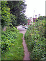
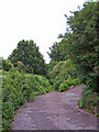
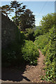
Footpath into Rosehill Road
This footpath links Rosehill Road to Higher Warberry Road, and then continues through The Copse to Grange Road and eventually, Windsor Road.
Image: © Richard Dorrell
Taken: 17 Jul 2008
0.03 miles
2
Path junction, Warberry Copse
East of Rosehill Road; the tracks remain close as they head to Grange Road.
Image: © Derek Harper
Taken: 15 May 2018
0.04 miles
3
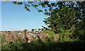
Safety fence by path, Warberry Copse
A warning on a dangerous drop down the steep hillside to a building site on Grange Road, where nine flats are being constructed.
Image: © Derek Harper
Taken: 15 May 2018
0.04 miles
4
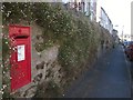
Postbox, Princes Road East, Torquay
This is George V postbox TQ1 218, on a wall almost covered in Erigeron.
Image: © Derek Harper
Taken: 31 Aug 2013
0.04 miles
5
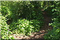
Footpath into The Copse
This footpath leads into the lower part of The Copse from the end of Higher Warberry Road.
Image: © Richard Dorrell
Taken: 17 Jul 2008
0.04 miles
6
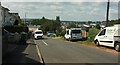
Princes Road East, Ellacombe
Taken a little further west along Image
Image: © Derek Harper
Taken: 29 Aug 2021
0.06 miles
7
Rosehill Road, Ellacombe
A reverse view of Image], as the track reaches the end of Higher Warberry Road, which the house on the right has as its address.
Image: © Derek Harper
Taken: 15 May 2018
0.06 miles
8
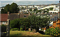
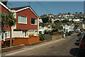
Ellacombe from Princes Road East
Taken further west along the road from Image
Image: © Derek Harper
Taken: 29 Aug 2021
0.06 miles
9
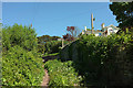
Rosehill Road, Ellacombe
This path is mapped as "Rosehill Road (Track)", and is seen from the end of Higher Warberry Road.
Image: © Derek Harper
Taken: 15 May 2018
0.06 miles
10
Denys Road, Ellacombe
On the right is the junction with Egerton Road.
Image: © Derek Harper
Taken: 29 Aug 2021
0.06 miles