IMAGES TAKEN NEAR TO
Deancombe, BUCKFASTLEIGH, TQ11 0LZ
Introduction
This page details the photographs taken nearby to TQ11 0LZ by members of the Geograph project.
The Geograph project started in 2005 with the aim of publishing, organising and preserving representative images for every square kilometre of Great Britain, Ireland and the Isle of Man.

There are currently over 7.5m images from over14,400 individuals and you can help contribute to the project by visiting https://www.geograph.org.uk
Image Map
Images are licensed for reuse under creativecommons.org/licenses/by-sa/2.0
Notes
- Clicking on the map will re-center to the selected point.
- The higher the marker number, the further away the image location is from the centre of the postcode.
Image Listing (3 Images Found)
Images are licensed for reuse under creativecommons.org/licenses/by-sa/2.0
Image
Details
Distance
1
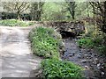
Bridge over the Moorshead Brook at Deancombe
This bridge carries an unmetalled track over the brook.
Image: © Tony Atkin
Taken: 8 Apr 2012
0.05 miles
3
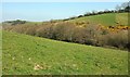
Valley of Moorshead Brook
Below Nurston, and seen from Dean Prior Footpath 10.
Image: © Derek Harper
Taken: 8 Apr 2017
0.25 miles