IMAGES TAKEN NEAR TO
Colston Road, BUCKFASTLEIGH, TQ11 0LW
Introduction
This page details the photographs taken nearby to Colston Road, TQ11 0LW by members of the Geograph project.
The Geograph project started in 2005 with the aim of publishing, organising and preserving representative images for every square kilometre of Great Britain, Ireland and the Isle of Man.

There are currently over 7.5m images from over14,400 individuals and you can help contribute to the project by visiting https://www.geograph.org.uk
Image Map
Images are licensed for reuse under creativecommons.org/licenses/by-sa/2.0
Notes
- Clicking on the map will re-center to the selected point.
- The higher the marker number, the further away the image location is from the centre of the postcode.
Image Listing (13 Images Found)
Images are licensed for reuse under creativecommons.org/licenses/by-sa/2.0
Image
Details
Distance
1
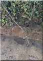
Old Milestone by Colston Cottages, Colston Road, Staverton parish
Carved stone post by the UC road, in parish of STAVERTON (SOUTH HAMS District), Colston Cottages, Colston Road, in base of stone wall, on East side of road. Erected by the Ashburton (Ashburton & Totnes Consolidated) turnpike trust in the 19th century.
Inscription unknown.
Milestone Society National ID: DV_TNBF03.
Image: © A Rosevear
Taken: 14 Feb 2013
0.01 miles
3
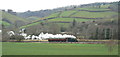
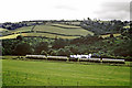
GWR steam train in the Dart Valley
A 'Prairie' tank engine is hauling a single-coach 'auto-train' (push-pull train) back towards Buckfastleigh from Totnes on what is now known as the South Devon Railway. http://www.southdevonrailway.co.uk/. Picture taken February 2013
A fascinating contrast with the 1969 picture Image: The engine in the 2013 picture is roughly where the left-hand end of the train is in the 1969 shot. Farming practices have changed too - some hedges grubbed out, wider access gates for bigger machinery, etc.
Image: © Edwin Graham
Taken: 22 Feb 2013
0.11 miles
4
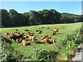
South Devon Cows?
I am aware that there's a breed of cow called South Devons, and they are this sort of colour, but I'm not clever enough to know if that's what these are.
Being beside the South Devon Railway isn't a good enough pedigree.
Image: © Des Blenkinsopp
Taken: 26 Aug 2016
0.11 miles
5
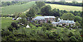
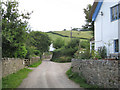
Rill Farm
A view from the opposite hillside of Rill Farm.
Image: © Mike Crowe
Taken: 1 Jun 2005
0.14 miles
6
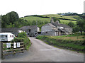
Beara Farm
South of Colston, a listed camping and caravanning site in a quiet spot near the River Dart.
Image: © Robin Stott
Taken: 28 Jul 2010
0.15 miles
7
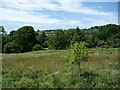
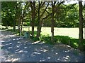
Grassland and trees alongside the Dart
Taken from an open train window on the South Devon Railway.
Image: © Christine Johnstone
Taken: 21 Jun 2010
0.15 miles
8
Train in the Dart valley, 1969
A push and pull train on what was then called the Dart Valley Railway, heading towards Totnes.
Image: © Robin Webster
Taken: 7 Jul 1969
0.16 miles
9
Harris Halt
This informal halt is not on the passenger timetable. Taken from an open train window on the South Devon Railway.
Image: © Christine Johnstone
Taken: 21 Jun 2010
0.17 miles
10
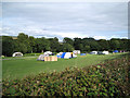
Camping at Beara Farm
South of Colston, a listed caravanning and camping site near the River Dart, which here runs among the trees.
Image: © Robin Stott
Taken: 28 Jul 2010
0.18 miles