IMAGES TAKEN NEAR TO
Colston Road, BUCKFASTLEIGH, TQ11 0LP
Introduction
This page details the photographs taken nearby to Colston Road, TQ11 0LP by members of the Geograph project.
The Geograph project started in 2005 with the aim of publishing, organising and preserving representative images for every square kilometre of Great Britain, Ireland and the Isle of Man.

There are currently over 7.5m images from over14,400 individuals and you can help contribute to the project by visiting https://www.geograph.org.uk
Image Map
Images are licensed for reuse under creativecommons.org/licenses/by-sa/2.0
Notes
- Clicking on the map will re-center to the selected point.
- The higher the marker number, the further away the image location is from the centre of the postcode.
Image Listing (18 Images Found)
Images are licensed for reuse under creativecommons.org/licenses/by-sa/2.0
Image
Details
Distance
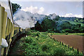
1
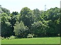
Wortley Copse
Taken from an open train window on the South Devon Railway.
Image: © Christine Johnstone
Taken: 21 Jun 2010
0.12 miles
3
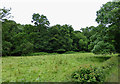
River Dart Flood Plain
The river is hidden from view by the trees. Taken from a passing train on the South Devon Railway.
Image: © Mary and Angus Hogg
Taken: 30 Jun 2016
0.15 miles
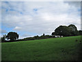
4
Entrance to Koo-Yong
One of a number of extensive, secluded properties enjoying views across the Dart Valley south of Buckfastleigh.
Image: © Robin Stott
Taken: 28 Jul 2010
0.16 miles
5
At the 5 1/4 mile post, 1969
A train on the then Dart Valley Railway rounds a long bend on the way to Totnes from Buckfastleigh. A push and pull or auto train of four coaches with the engine in the middle, with its chimney leading. The engine is just at the white distance post.
Image: © Robin Webster
Taken: 7 Jul 1969
0.16 miles
6
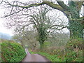
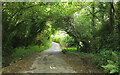
Lane near Thistlemuir
Looking WSW along this lane which winds along the right side of the Dart valley.
Image: © Derek Harper
Taken: 21 Apr 2006
0.19 miles
7
Countryside near Cuming Farm
Taken close to Image], looking across a side valley of the Dart.
Image: © Derek Harper
Taken: 6 Oct 2021
0.20 miles
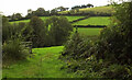
8
Climbing west from Cuming Farm
The farm is in a deep lush valley, reached by steep, narrow, winding lanes. The ascent from the farm by car to this point is a first-gear affair.
Image: © Robin Stott
Taken: 28 Jul 2010
0.21 miles
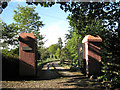
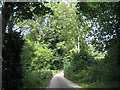
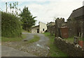
9
Colston Road
A very minor lane to Buckfastleigh.
Image: © Derek Harper
Taken: 6 Oct 2021
0.21 miles
10
Cuming Farm
The new house mentioned at Image Seen from what must be one of South Devon's trickiest lanes to drive along - but a delight to walk.
Image: © Derek Harper
Taken: 6 Oct 2021
0.21 miles