IMAGES TAKEN NEAR TO
BUCKFASTLEIGH, TQ11 0LE
Introduction
This page details the photographs taken nearby to TQ11 0LE by members of the Geograph project.
The Geograph project started in 2005 with the aim of publishing, organising and preserving representative images for every square kilometre of Great Britain, Ireland and the Isle of Man.

There are currently over 7.5m images from over14,400 individuals and you can help contribute to the project by visiting https://www.geograph.org.uk
Image Map
Images are licensed for reuse under creativecommons.org/licenses/by-sa/2.0
Notes
- Clicking on the map will re-center to the selected point.
- The higher the marker number, the further away the image location is from the centre of the postcode.
Image Listing (23 Images Found)
Images are licensed for reuse under creativecommons.org/licenses/by-sa/2.0
Image
Details
Distance
1
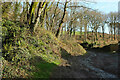
Bridleway, Lower Combe
A little further along Staverton bridleway 17 from Image
Image: © Derek Harper
Taken: 20 Dec 2020
0.01 miles
2
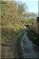
Bridleway, Lower Combe
Seen looking right along Staverton bridleway 17 from the bend in Image
Image: © Derek Harper
Taken: 20 Dec 2020
0.02 miles
3
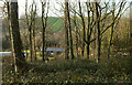
Woodland, Lower Combe
Looking left from Image], with buildings on the valley floor seen through the trees.
Image: © Derek Harper
Taken: 20 Dec 2020
0.03 miles
4
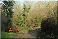
Bridleway, Lower Combe
Looking the other way from Image], as Staverton bridleway 17 turns sharply right after a straight stretch.
Image: © Derek Harper
Taken: 20 Dec 2020
0.03 miles
5
Bridleway, Lower Combe
Taken from further north on Staverton bridleway 17 than Image
Image: © Derek Harper
Taken: 20 Dec 2020
0.03 miles
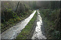
6
Bridleway, Lower Combe
Puddles on Staverton bridleway 17.
Image: © Derek Harper
Taken: 20 Dec 2020
0.04 miles
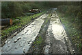
7
Bridleway, Lower Combe
Staverton Bridleway 17 leads off (through puddles) the lane up the Combe valley, which is about to turn sharply up the valley side - its wiggling course is seen in Image This must have been a busy spot when the mine shown in Image was in operation.
Image: © Derek Harper
Taken: 5 Dec 2008
0.05 miles
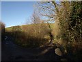
8
Track junction, Lower Combe
Staverton bridleway 17 bends sharp left uphill, while a track which is not a right of way continues climbing more gently along the upper edge of Combe Plantation.
Image: © Derek Harper
Taken: 20 Dec 2020
0.06 miles
9
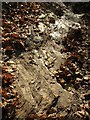
Slate bridleway, near Penn Recca
This requires some explanation. The area at the bottom of the photo is a little way in front of the photographer's feet. The bed of the path (Staverton Bridleway 17) is crossing layers of slate as it drops steeply towards the top right-hand corner. Autumn leaves edge it.
Image: © Derek Harper
Taken: 5 Dec 2008
0.07 miles
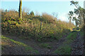
10
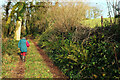
Bridleway to Higher Penn
Staverton bridleway 17 climbs steeply into the wood containing the former Penn Recca slate mine.
Image: © Derek Harper
Taken: 20 Dec 2020
0.07 miles