IMAGES TAKEN NEAR TO
BUCKFASTLEIGH, TQ11 0JZ
Introduction
This page details the photographs taken nearby to TQ11 0JZ by members of the Geograph project.
The Geograph project started in 2005 with the aim of publishing, organising and preserving representative images for every square kilometre of Great Britain, Ireland and the Isle of Man.

There are currently over 7.5m images from over14,400 individuals and you can help contribute to the project by visiting https://www.geograph.org.uk
Image Map
Images are licensed for reuse under creativecommons.org/licenses/by-sa/2.0
Notes
- Clicking on the map will re-center to the selected point.
- The higher the marker number, the further away the image location is from the centre of the postcode.
Image Listing (9 Images Found)
Images are licensed for reuse under creativecommons.org/licenses/by-sa/2.0
Image
Details
Distance
1
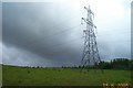
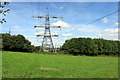
Near Staverton sub station
Pylons dominate the otherwise very agricultural nature of this area of the South Hams.
Image: © Richard Knights
Taken: 15 Jun 2005
0.04 miles
2
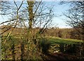
Gate at Abham
By which Staverton Footpath 11 leaves a short field access track through trees from the lane and enters the field beyond.
Image: © Derek Harper
Taken: 5 Dec 2008
0.04 miles
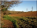
3
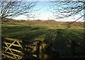
Field, Abham
Looking across the gate shown in Image and the field beyond, which is crossed by Staverton Footpath 11. The pylons mark the site of the Abham regional electricity transformer site.
Image: © Derek Harper
Taken: 5 Dec 2008
0.05 miles
4
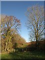
Footpath from Abham
Staverton Footpath 11 crosses an unnamed tributary of the Dart by this stile and then proceeds along the generous head path between stream and ploughed field.
Image: © Derek Harper
Taken: 5 Dec 2008
0.13 miles
5
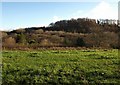
Abham Copse
Seen across a field and valley from the green lane mentioned in Image
Image: © Derek Harper
Taken: 5 Dec 2008
0.16 miles
6
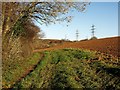
Staverton Footpath 11
The footpath is generously provided for as it runs along the foot of a tilled field and beside a tributary of the Dart on the left, which is hidden among trees. Three separate pylon lines in the background have just emerged from the nearby electricity transformer site, a short way off to the left.
Image: © Derek Harper
Taken: 5 Dec 2008
0.21 miles
7
Pylon near the Electricity Grid Sub-Station
A high tension powerline leaving the sub-station which is just beyond the trees.
Image: © Tony Atkin
Taken: 26 Aug 2017
0.23 miles
8

Lane in Clay Copse
Looking in the opposite direction to Image
Image: © Derek Harper
Taken: 1 Sep 2022
0.24 miles
9
Field north of Abham
A similar view to Image, taken a few metres further north, with the edge of the field curving round towards the gate onto the lane from Bumpston Cross to Staverton.
Image: © Derek Harper
Taken: 5 Dec 2008
0.24 miles