IMAGES TAKEN NEAR TO
BUCKFASTLEIGH, TQ11 0HP
Introduction
This page details the photographs taken nearby to TQ11 0HP by members of the Geograph project.
The Geograph project started in 2005 with the aim of publishing, organising and preserving representative images for every square kilometre of Great Britain, Ireland and the Isle of Man.

There are currently over 7.5m images from over14,400 individuals and you can help contribute to the project by visiting https://www.geograph.org.uk
Image Map
Images are licensed for reuse under creativecommons.org/licenses/by-sa/2.0
Notes
- Clicking on the map will re-center to the selected point.
- The higher the marker number, the further away the image location is from the centre of the postcode.
Image Listing (16 Images Found)
Images are licensed for reuse under creativecommons.org/licenses/by-sa/2.0
Image
Details
Distance
2
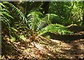
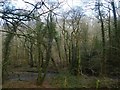
Fern, Burchetts Wood
I think this is male fern, Dryopteris filix-mas, by the Dartmoor Way following West Buckfastleigh bridleway 1.
Image: © Derek Harper
Taken: 18 Jun 2017
0.13 miles
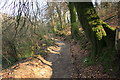
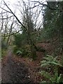
3

Track filled with leaves in Burchetts Wood
Evidently once used as a track, but not used now
Image: © David Smith
Taken: 5 Feb 2020
0.15 miles
4
Dartmoor Way
On the well maintained bridleway that runs from Mill Leat to Burchetts Lodge; it runs along Holy Brook and through the National Trust Burchetts Wood.
Image: © Guy Wareham
Taken: 17 Apr 2010
0.16 miles
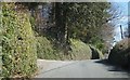
5

Hillside paddocks
Small hillside paddocks reach down into the bottom of the valley on the other side of the road from Hawson Court. In the distance the edge of Dartmoor is visible.
Image: © Sarah Smith
Taken: 7 Jun 2011
0.17 miles
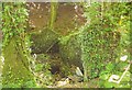
7
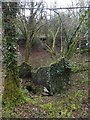
Ruin in former quarry, Burchetts Wood
The ruined building houses a bearing for a water wheel; the 1890 maps mark this as a former quarry, but do not elaborate. So the ruin is well over 130 years old.
Image: © David Smith
Taken: 5 Feb 2020
0.19 miles
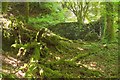
8
Path and former leat, Burchetts Wood
The leat probably fed a waterwheel in the quarry to the east.
Image: © David Smith
Taken: 5 Feb 2020
0.20 miles
9
Ruin near Holy Brook
Beside West Buckfastleigh bridleway 1 (and the Dartmoor Way (the LDP https://www.ldwa.org.uk/ldp/members/show_path.php?path_name=Dartmoor+Way ) about 350 ESE of Mill Leat, and probably associated with an adjacent disused quarry.
Image: © Derek Harper
Taken: 18 Jun 2017
0.20 miles