IMAGES TAKEN NEAR TO
BUCKFASTLEIGH, TQ11 0HN
Introduction
This page details the photographs taken nearby to TQ11 0HN by members of the Geograph project.
The Geograph project started in 2005 with the aim of publishing, organising and preserving representative images for every square kilometre of Great Britain, Ireland and the Isle of Man.

There are currently over 7.5m images from over14,400 individuals and you can help contribute to the project by visiting https://www.geograph.org.uk
Image Map
Images are licensed for reuse under creativecommons.org/licenses/by-sa/2.0
Notes
- Clicking on the map will re-center to the selected point.
- The higher the marker number, the further away the image location is from the centre of the postcode.
Image Listing (11 Images Found)
Images are licensed for reuse under creativecommons.org/licenses/by-sa/2.0
Image
Details
Distance
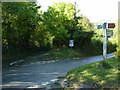
1
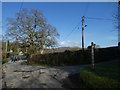
Looking north from Fritz's Grave crossroads
Two stories attempt to explain the name; one, of a tramp called Fritz who lived in a hut here and wished to be buried here; the other of a suicide. It is also suggested that the name is a corruption of Furzes.
Image: © David Smith
Taken: 5 Feb 2020
0.12 miles
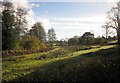
2
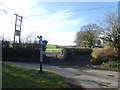
The signpost at Fritz's Grave crossroads
Image: © David Smith
Taken: 5 Feb 2020
0.13 miles
3
View from Hockmoor Head #2
Looking right from the same spot as Image], across the Holy Brook and the Dart valleys, and several woods. The buildings visible on the left in the distance are around Hele.
Image: © Derek Harper
Taken: 18 Jun 2017
0.15 miles
5
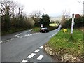
Crooked crossroads at Hockmoor Head, near Buckfast
Image: © Ruth Sharville
Taken: 11 Oct 2014
0.18 miles
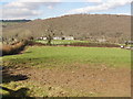
6
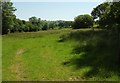
Field between Holy Brook and leat
Taken just across the bridge shown in Image Holy Brook flows behind the bushes on the left; the Mill Leat, taken off it just over 200 metres upstream, is already several metres higher, running along the contour above this meadow and past the trees.
Image: © Derek Harper
Taken: 11 Nov 2012
0.19 miles
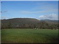
7
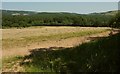
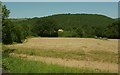
Hockmoor
The field in the foreground is called Hockmoor on the OS map. The wooded hill beyond is part of Hembury Woods.
Image: © Tony Atkin
Taken: 17 Feb 2013
0.19 miles
9
View from Hockmoor Head
A summer version of the winter scene in Image, also from Hockmoor Head, the junction shown in http://www.geograph.org.uk/search.php?i=72905095 . The new timber structure is at Hockmoor Farm; Hembury Woods are across thee Holy Brook valley.
Image: © Derek Harper
Taken: 18 Jun 2017
0.21 miles
10
Holy Brook valley
An autumnal version of (roughly) this view, taken a little further down the lane near the bridge, is at Image This close to the upper edge of the meadow by the leat.
Image: © Derek Harper
Taken: 18 Jun 2017
0.21 miles