IMAGES TAKEN NEAR TO
Buckfast Road, BUCKFASTLEIGH, TQ11 0FH
Introduction
This page details the photographs taken nearby to Buckfast Road, TQ11 0FH by members of the Geograph project.
The Geograph project started in 2005 with the aim of publishing, organising and preserving representative images for every square kilometre of Great Britain, Ireland and the Isle of Man.

There are currently over 7.5m images from over14,400 individuals and you can help contribute to the project by visiting https://www.geograph.org.uk
Image Map
Images are licensed for reuse under creativecommons.org/licenses/by-sa/2.0
Notes
- Clicking on the map will re-center to the selected point.
- The higher the marker number, the further away the image location is from the centre of the postcode.
Image Listing (104 Images Found)
Images are licensed for reuse under creativecommons.org/licenses/by-sa/2.0
Image
Details
Distance
1
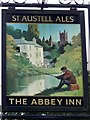
Sign for the Abbey Inn
The sign shows the inn and Buckfast Abbey.
Image: © Maigheach-gheal
Taken: 13 May 2009
0.06 miles
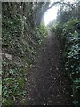
2
Buckfast : Footpath
Looking along a footpath through some woodlands.
Image: © Lewis Clarke
Taken: 15 Jul 2019
0.06 miles
3
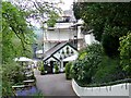
The Abbey Inn, Buckfast
Looking towards the Dart Bridge from the Abbey Inn.
Image: © Maigheach-gheal
Taken: 13 May 2009
0.07 miles
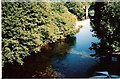
4
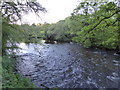
River Dart at The Abbey Inn, Buckfastleigh
Image: © Maurice D Budden
Taken: 13 May 2018
0.07 miles
5
Buckfast, Abbey Inn
Public house with accommodation on Buckfast Road. Back bar down steps; drinking front, dining left; terrace with river views. Cask ales on offer: St Austell Abbey Best, Proper Job, Tribute.
Image: © Mike Faherty
Taken: 2 Apr 2017
0.08 miles
6
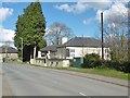
Buckfast : David Clarke Commercial Repairs
A repair centre on Buckfast Road.
Image: © Lewis Clarke
Taken: 15 Jul 2019
0.09 miles
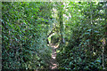
7
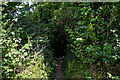
Buckfast : Footpath
A footpath heading through some woodland.
Image: © Lewis Clarke
Taken: 15 Jul 2019
0.10 miles
8
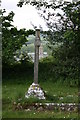
Holy Trinity Churchyard
This memorial cross lies on the northern edge of the graveyard at Holy Trinity Church, Buckfastleigh. Behind the hedge is a quarry cliff, and framed in the hedge can be seen the tower of St Mary's Abbey at Buckfast. This belongs to a Catholic Benedictine abbey and was rebuilt at the start of the C20th on the footprint of an abbey dissolved by King Henry in the C16th. See Image and Image
Image: © Adrian Platt
Taken: 20 May 2007
0.11 miles