IMAGES TAKEN NEAR TO
The Orchard, Old Totnes Road, BUCKFASTLEIGH, TQ11 0FG
Introduction
This page details the photographs taken nearby to The Orchard, Old Totnes Road, TQ11 0FG by members of the Geograph project.
The Geograph project started in 2005 with the aim of publishing, organising and preserving representative images for every square kilometre of Great Britain, Ireland and the Isle of Man.

There are currently over 7.5m images from over14,400 individuals and you can help contribute to the project by visiting https://www.geograph.org.uk
Image Map
Images are licensed for reuse under creativecommons.org/licenses/by-sa/2.0
Notes
- Clicking on the map will re-center to the selected point.
- The higher the marker number, the further away the image location is from the centre of the postcode.
Image Listing (226 Images Found)
Images are licensed for reuse under creativecommons.org/licenses/by-sa/2.0
Image
Details
Distance
1
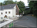
The Orchard, Old Totnes Road
The A38 flyover is just beyond this recently completed development. Aerial photos still show a large house and grounds here.
Image: © Robin Stott
Taken: 28 Jul 2010
0.02 miles
2
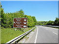
The A38 northbound near the Buckfast turn off
Image: © Ian S
Taken: 26 May 2013
0.03 miles
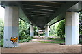
3
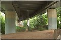
Under the A38, Buckfastleigh
The dual carriageway is elevated for some distance as it passes Buckfastleigh. Here seen from the Old Totnes Road, it crosses the River Mardle a few metres away.
Image: © Derek Harper
Taken: 21 Jul 2016
0.04 miles
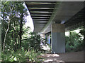
5
Underneath the A38
The main A38 road was remade as a dual carriageway in the 1970's and is difficult to ignore in Buckfastleigh as it runs close to the edge of town on an elevated roadway.
Image: © Tony Atkin
Taken: 29 Aug 2008
0.05 miles
6
A38 from Old Totnes Road
Engineering! An underrated profession. The view in the opposite direction is Image
Image: © Robin Stott
Taken: 28 Jul 2010
0.05 miles
7
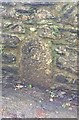
Old Bridge Marker by Station Road, Buckfastleigh
Bridge Marker by the UC road, in parish of Buckfastleigh (Teignbridge District), Station Road, 15m West of junction with Dart Bridge Road, in wall, opposite The Rock Nursing Home in private car park.
Grade II listed.
List Entry Number: 1209075 https://historicengland.org.uk/listing/the-list/list-entry/1209075
Surveyed
Milestone Society National ID: DV_PLEX20br
Image: © Alan Rosevear
Taken: 14 Feb 2013
0.06 miles
8
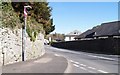
The Old Main Road
Before the new dual carriageway was built in the 1970's this was part of the main road between Plymouth and Exeter. Back then it would have been nose to tail traffic all day and you would be very unlikely to get a traffic free photograph.
Image: © Tony Atkin
Taken: 29 Aug 2008
0.06 miles
9
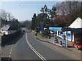
Jet petrol station on edge of Buckfastleigh
Image: © David Smith
Taken: 29 Feb 2012
0.07 miles
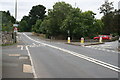
10
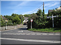
Old Totnes Road joins Strode Road
One of those places where everything is vertical — in its own way. It says 'Elliott Plain' on the shaft of the signpost. Elliott Plain is the road into Buckfastleigh from this junction, behind the camera.
Image: © Robin Stott
Taken: 28 Jul 2010
0.07 miles