IMAGES TAKEN NEAR TO
Tweenaways, BUCKFASTLEIGH, TQ11 0DW
Introduction
This page details the photographs taken nearby to Tweenaways, TQ11 0DW by members of the Geograph project.
The Geograph project started in 2005 with the aim of publishing, organising and preserving representative images for every square kilometre of Great Britain, Ireland and the Isle of Man.

There are currently over 7.5m images from over14,400 individuals and you can help contribute to the project by visiting https://www.geograph.org.uk
Image Map
Images are licensed for reuse under creativecommons.org/licenses/by-sa/2.0
Notes
- Clicking on the map will re-center to the selected point.
- The higher the marker number, the further away the image location is from the centre of the postcode.
Image Listing (15 Images Found)
Images are licensed for reuse under creativecommons.org/licenses/by-sa/2.0
Image
Details
Distance
1
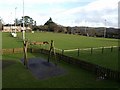
Duckspond Playing Field, Buckfastleigh
Seen from the path beside Elm Bank. On the left is the clubhouse. Home of soccer club Buckfastleigh Rangers.
Image: © Derek Harper
Taken: 16 Jan 2009
0.08 miles
2
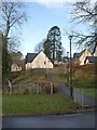
Path to Fullaford Park
The path leads from Duckspond Road, close to Fullaford Pool Cross, to a modern estate.
Image: © Derek Harper
Taken: 16 Jan 2009
0.11 miles
3
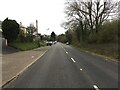
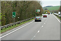
Minor road
The B3380, heading towards Buckfastleigh.
Image: © jeff collins
Taken: 24 Mar 2021
0.12 miles
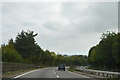
4
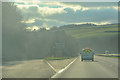
Buckfastleigh : Devon Expressway A38
Looking along the Devon Expressway.
Image: © Lewis Clarke
Taken: 3 Dec 2019
0.13 miles
6
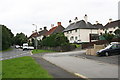
Suburban Housing on Plymouth Road, Buckfastleigh
Image: © Tony Atkin
Taken: 29 Aug 2008
0.14 miles
8
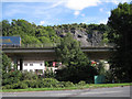
Elevated A38 by Whitecleaves Quarry
Photographed from Plymouth Road. The stone quarry was fully active from the 1950s until 1988. Since 2008 the site has been developed by Gilpin Demolition as a recycling facility for construction and building waste. The Devon-based company specialises in the demolition of bridges, marine demolition and asbestos removal and has an impressive portfolio. http://www.gilpindemolition.com/ http://www.derelictplaces.co.uk/main/showthread.php?p=55069
Image: © Robin Stott
Taken: 28 Jul 2010
0.18 miles
9
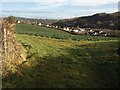
Housing on Timbers Road, Buckfastleigh
A view from the gateway shown in Image across a field towards the Dean valley. The housing is on the southern outskirts of Buckfastleigh.
Image: © Derek Harper
Taken: 16 Jan 2009
0.18 miles
10
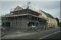
New Housing at Halfmoon
New houses being built at Halfmoon, situated between Buckfast and Dean Prior.
Image: © Mike Crowe
Taken: 2 Jun 2005
0.19 miles