IMAGES TAKEN NEAR TO
Bigadon Lane, BUCKFASTLEIGH, TQ11 0DT
Introduction
This page details the photographs taken nearby to Bigadon Lane, TQ11 0DT by members of the Geograph project.
The Geograph project started in 2005 with the aim of publishing, organising and preserving representative images for every square kilometre of Great Britain, Ireland and the Isle of Man.

There are currently over 7.5m images from over14,400 individuals and you can help contribute to the project by visiting https://www.geograph.org.uk
Image Map
Images are licensed for reuse under creativecommons.org/licenses/by-sa/2.0
Notes
- Clicking on the map will re-center to the selected point.
- The higher the marker number, the further away the image location is from the centre of the postcode.
Image Listing (121 Images Found)
Images are licensed for reuse under creativecommons.org/licenses/by-sa/2.0
Image
Details
Distance
1

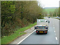
Buckfastleigh : Devon Expressway A38
Looking along the A38.
Image: © Lewis Clarke
Taken: 3 Dec 2019
0.03 miles
2

The A38 northbound towards the Buckfast turn off
Image: © Ian S
Taken: 26 May 2013
0.04 miles
4
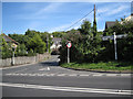
Old Totnes Road joins Strode Road
One of those places where everything is vertical — in its own way. It says 'Elliott Plain' on the shaft of the signpost. Elliott Plain is the road into Buckfastleigh from this junction, behind the camera.
Image: © Robin Stott
Taken: 28 Jul 2010
0.13 miles
5
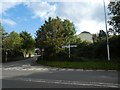
Signpost "Elliott Plain" Buckfastleigh
Elliott Plain is the name of the short road opposite the sign (behind the photographer)
Image: © David Smith
Taken: 19 Oct 2019
0.13 miles
6
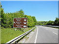
The A38 northbound near the Buckfast turn off
Image: © Ian S
Taken: 26 May 2013
0.13 miles
7
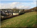
Buckfastleigh from Church Steps
From around the point where Image meet Buckfastleigh Footpath 6. On the extreme left is Image The River Mardle runs between the cream-coloured house and the buildings to its left.
Image: © Derek Harper
Taken: 16 Jan 2009
0.14 miles
8
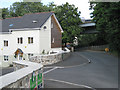
The Orchard, Old Totnes Road
The A38 flyover is just beyond this recently completed development. Aerial photos still show a large house and grounds here.
Image: © Robin Stott
Taken: 28 Jul 2010
0.14 miles
9
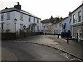
Elliot Plain, Buckfastleigh
The street leaves the bottom of Fore Street, linking it across Dean Burn with Strode Road.
The conservation area appraisal has these comments about the house on the left:
"Vine Cottage: Grade II: Along with its neighbour, 19 Elliot Place {they mean Elliot Plain}, this building is the focal point at the bottom of Fore St. Like the Globe Inn it is a simple but pleasant building that gently deflects the eye along Station Road and Elliot Plain. Built on a bridge over the Dean Burn, this makes it an unusual building and the railings and gate are a positive feature." http://www.dartmoor-npa.gov.uk/li-buckfastleigh.pdf
More architectural detail is at http://www.imagesofengland.org.uk/Details/Default.aspx?id=392263&mode=quick and http://www.imagesofengland.org.uk/Details/Default.aspx?id=392315&mode=quick
Image: © Derek Harper
Taken: 16 Jan 2009
0.14 miles
10
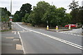
The Old Main Road
Before the new dual carriageway was built in the 1970's this was part of the main road between Plymouth and Exeter. Back then it would have been nose to tail traffic all day and you would be very unlikely to get a traffic free photograph.
Image: © Tony Atkin
Taken: 29 Aug 2008
0.14 miles