IMAGES TAKEN NEAR TO
Plymouth Road, BUCKFASTLEIGH, TQ11 0DG
Introduction
This page details the photographs taken nearby to Plymouth Road, TQ11 0DG by members of the Geograph project.
The Geograph project started in 2005 with the aim of publishing, organising and preserving representative images for every square kilometre of Great Britain, Ireland and the Isle of Man.

There are currently over 7.5m images from over14,400 individuals and you can help contribute to the project by visiting https://www.geograph.org.uk
Image Map
Images are licensed for reuse under creativecommons.org/licenses/by-sa/2.0
Notes
- Clicking on the map will re-center to the selected point.
- The higher the marker number, the further away the image location is from the centre of the postcode.
Image Listing (87 Images Found)
Images are licensed for reuse under creativecommons.org/licenses/by-sa/2.0
Image
Details
Distance
1
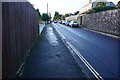
Plymouth Road, Buckfastleigh
Looking Southwest away from the town centre.
Image: © jeff collins
Taken: 10 Dec 2014
0.03 miles
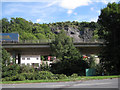
2
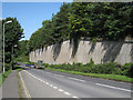
Strode Road, Buckfastleigh
Looking northeast. The massive retaining wall supports the elevated A38 dual carriageway, here screened by conifers.
Image: © Robin Stott
Taken: 28 Jul 2010
0.03 miles
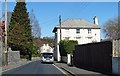
4
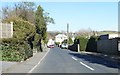
View along Plymouth Road
A busy road before the bypass was built.
Image: © Fernweh
Taken: 15 Mar 2014
0.06 miles
5
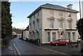
House on Plymouth Road, Buckfastleigh
Tollmarsh, an impressive villa southwest of the town, with classical pediments to many of the windows and rusticated quoins. Built about 1870 for the Hamlyns, important mill-owners in the nineteenth century, "tanners, woolstaplers, serge and blanket manufacturers" http://freepages.genealogy.rootsweb.ancestry.com/~valhender/dirtrans/mor1870/buckfastleigh.htm . Further architectural details are at http://www.imagesofengland.org.uk/Details/Default.aspx?id=392304&mode=quick
Image: © Derek Harper
Taken: 16 Jan 2009
0.06 miles
6
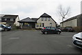
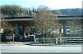
Buckfastleigh Medical Centre
Buckfastleigh Medical Centre, with free parking.
Image: © John C
Taken: 22 Feb 2018
0.07 miles
8

Buckfastleigh : Devon Expressway A38
Looking along the Devon Expressway.
Image: © Lewis Clarke
Taken: 3 Dec 2019
0.08 miles
9
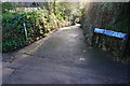
Little Bossell Lane, Buckfastleigh
A handy shortcut between Bossell Road and Plymouth Road. Seen here looking towards Plymouth Road.
Image: © jeff collins
Taken: 10 Dec 2014
0.08 miles
10
Elevated A38 by Whitecleaves Quarry
Photographed from Plymouth Road. The stone quarry was fully active from the 1950s until 1988. Since 2008 the site has been developed by Gilpin Demolition as a recycling facility for construction and building waste. The Devon-based company specialises in the demolition of bridges, marine demolition and asbestos removal and has an impressive portfolio. http://www.gilpindemolition.com/ http://www.derelictplaces.co.uk/main/showthread.php?p=55069
Image: © Robin Stott
Taken: 28 Jul 2010
0.09 miles