IMAGES TAKEN NEAR TO
Plymouth Road, BUCKFASTLEIGH, TQ11 0DB
Introduction
This page details the photographs taken nearby to Plymouth Road, TQ11 0DB by members of the Geograph project.
The Geograph project started in 2005 with the aim of publishing, organising and preserving representative images for every square kilometre of Great Britain, Ireland and the Isle of Man.

There are currently over 7.5m images from over14,400 individuals and you can help contribute to the project by visiting https://www.geograph.org.uk
Image Map
Images are licensed for reuse under creativecommons.org/licenses/by-sa/2.0
Notes
- Clicking on the map will re-center to the selected point.
- The higher the marker number, the further away the image location is from the centre of the postcode.
Image Listing (149 Images Found)
Images are licensed for reuse under creativecommons.org/licenses/by-sa/2.0
Image
Details
Distance

4
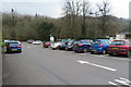
Plymouth Road car park, Buckfastleigh
Plymouth Road car park, Buckfastleigh, also accommodates public toilets and bus stop.
Image: © John C
Taken: 22 Feb 2018
0.04 miles
5
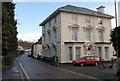
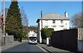
House on Plymouth Road, Buckfastleigh
Tollmarsh, an impressive villa southwest of the town, with classical pediments to many of the windows and rusticated quoins. Built about 1870 for the Hamlyns, important mill-owners in the nineteenth century, "tanners, woolstaplers, serge and blanket manufacturers" http://freepages.genealogy.rootsweb.ancestry.com/~valhender/dirtrans/mor1870/buckfastleigh.htm . Further architectural details are at http://www.imagesofengland.org.uk/Details/Default.aspx?id=392304&mode=quick
Image: © Derek Harper
Taken: 16 Jan 2009
0.04 miles
6
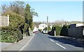
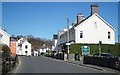
View along Plymouth Road
A busy road before the bypass was built.
Image: © Fernweh
Taken: 15 Mar 2014
0.04 miles
7
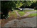
Town Mill Leat on Plymouth Road, Buckfastleigh
"At some point, possibly early in the development of the settlement,
the Town Mill Leat was formed to take water from the Dean Burn some
way to the south west. This brought water into the heart of Lower Town
and remains a distinctive feature today." http://www.dartmoor-npa.gov.uk/pages_9-19_from_buckfastleigh-2.pdf
Image: © Derek Harper
Taken: 16 Jan 2009
0.05 miles
8
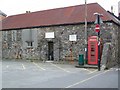
Telephone box, Buckfastleigh
K6 style telephone box on Plymouth Road.
Image: © Maigheach-gheal
Taken: 13 May 2009
0.05 miles
9
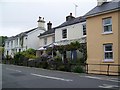
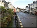
Housing on Plymouth Road, Buckfastleigh
A variety of housing styles on this residential street.
Image: © Maigheach-gheal
Taken: 13 May 2009
0.05 miles