IMAGES TAKEN NEAR TO
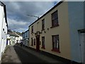
Plymouth Road, BUCKFASTLEIGH, TQ11 0DA
Introduction
This page details the photographs taken nearby to Plymouth Road, TQ11 0DA by members of the Geograph project.
The Geograph project started in 2005 with the aim of publishing, organising and preserving representative images for every square kilometre of Great Britain, Ireland and the Isle of Man.

There are currently over 7.5m images from over14,400 individuals and you can help contribute to the project by visiting https://www.geograph.org.uk
Image Map
Images are licensed for reuse under creativecommons.org/licenses/by-sa/2.0
Notes
- Clicking on the map will re-center to the selected point.
- The higher the marker number, the further away the image location is from the centre of the postcode.
Image Listing (166 Images Found)
Images are licensed for reuse under creativecommons.org/licenses/by-sa/2.0
Image
Details
Distance
1
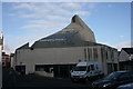
St Luke's Church, Buckfastleigh
The rear of this new striking church, built to replace Holy Trinity church. The lower ground floor is used as a community space, hence the Children's Centre vehicle which is based here. See Image, and for Holy Trinity Church, see Image
A campanile was added in summer 2009 to complete the church, see Image and Image to see this.
Image: © Adrian Platt
Taken: 5 Jan 2009
0.01 miles
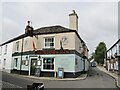
2
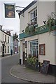
The Global Panic?
Clearly the sign indicates licensee of The Globe had anticipated being mobbed out by a Coach Party of CAMRA members who had been visiting Image However we did drink Image dry of Real Ale on what turned out to be their last day trading before calling time for the very last time. The White Hart in the background is in Plymouth St.
Image: © Glyn Baker
Taken: 31 Mar 2012
0.02 miles
3
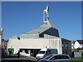
St Luke's church, Buckfastleigh
A modern church with meeting rooms below, which can be accessed from the church or this car park.
Image: © David Smith
Taken: 2 Mar 2011
0.02 miles
4
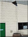
Detail of the drain on St Luke's church
In place of a downspout, there is a chain to guide the water that runs off the roof. This is similar to the drains on Chinese and Japanese buildings. It presumably is easier to keep clear of leaves than a normal downspout.
Image: © David Smith
Taken: 2 Mar 2011
0.02 miles
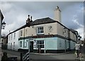
5
The Globe Inn, Buckfastleigh
The sign is unusual - a spherical globe, not a two-dimensional picture
Image: © David Smith
Taken: 19 Oct 2019
0.02 miles
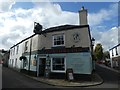
7
Buckfastleigh - The Globe Inn
Historic pub at the fork between Plymouth Road (l) and Chapel Street (r).
Image: © Colin Smith
Taken: 25 Jul 2021
0.02 miles
8

The King's Arms, Buckfastleigh
Public house with accommodation built circa 1820.
Image: © Maigheach-gheal
Taken: 13 May 2009
0.02 miles
9
The Globe Inn, Buckfastleigh
Has a dramatic pub sign,
Image: © Jonathan Thacker
Taken: 16 Sep 2017
0.02 miles
10

St Luke's Church, Buckfastleigh
This very modern church was opened in 2002 on the site of a CofE chapel to replace Holy Trinity Church Image which was burnt out in 1992. It provides a town centre church more accessible than Holy Trinity. It is also used as the church hall (see Image).
It's difficult getting a good image as this side is usually in shadow, and the area in front of the porch often has cars parked on it, one day I will catch it empty!
Image: © Adrian Platt
Taken: 5 Jan 2009
0.02 miles