IMAGES TAKEN NEAR TO
Station Road, BUCKFASTLEIGH, TQ11 0BU
Introduction
This page details the photographs taken nearby to Station Road, TQ11 0BU by members of the Geograph project.
The Geograph project started in 2005 with the aim of publishing, organising and preserving representative images for every square kilometre of Great Britain, Ireland and the Isle of Man.

There are currently over 7.5m images from over14,400 individuals and you can help contribute to the project by visiting https://www.geograph.org.uk
Image Map
Images are licensed for reuse under creativecommons.org/licenses/by-sa/2.0
Notes
- Clicking on the map will re-center to the selected point.
- The higher the marker number, the further away the image location is from the centre of the postcode.
Image Listing (180 Images Found)
Images are licensed for reuse under creativecommons.org/licenses/by-sa/2.0
Image
Details
Distance
1

Courtyard off Fore Street, Buckfastleigh
Entered through an archway bridging two houses midway along Fore Street
Image: © Derek Voller
Taken: 16 Jun 2014
0.01 miles
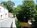
2
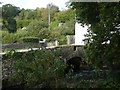
Station Road bridge over River Mardle, Buckfastleigh
The bridge is at the confluence of the Mardle with the Dean Burn
Image: © David Smith
Taken: 19 Oct 2019
0.01 miles
3
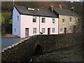
Duck and Cottages, Buckfastleigh
The muscovy duck stands on the parapet of a bridge carrying Station Road over the River Mardle. Directly below the camera, the Dean Burn joins the river.
From http://www.dartmoor-npa.gov.uk/li-buckfastleigh.pdf: "This row of four cottages occupies a focal point next to Church Bridge. They are very prominent in views at the south end of the town."
Image: © Derek Harper
Taken: 16 Jan 2009
0.02 miles
4
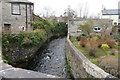
River Mardle in Buckfastleigh
The River Mardle passing through the village, as seen from the junction of Fore Street and Station Road.
Image: © John C
Taken: 22 Feb 2018
0.02 miles
6
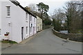
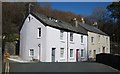
Station Road, Buckfastleigh
Station Road looking eastwards out of the village towards the direction of the Railway Station
Image: © John C
Taken: 22 Feb 2018
0.02 miles
7
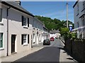
Station Road, Buckfastleigh
The station is at least five minutes walk from the village centre.
Image: © Christine Johnstone
Taken: 21 Jun 2010
0.02 miles
8
The Orchard Millennium Green, Buckfastleigh
Image: © David Smith
Taken: 19 Oct 2019
0.02 miles
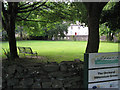
9
Brook alongside Station Road, Buckfastleigh
There is a small park to the right of the stream.
Image: © Christine Johnstone
Taken: 21 Jun 2010
0.03 miles
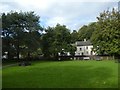
10
Orchard Millennium Green, Buckfastleigh
"A well used green space close to the town centre was enhanced in celebration of the millennium. With the Mardle on its north side and Dean Burn to the west the sound of running water is ever-present, as are the ducks that roam around during the daytime." – Buckfastleigh Conservation Area Appraisal, Dartmoor National Park Authority March 2005. Also known as Millman's Orchard. The sign asserts that it was an initiative of the Countryside Agency. The footbridge across the Mardle at the back, left, is a replacement financed by a grant.
Image: © Robin Stott
Taken: 28 Jul 2010
0.03 miles