IMAGES TAKEN NEAR TO
Chapel Street, BUCKFASTLEIGH, TQ11 0AD
Introduction
This page details the photographs taken nearby to Chapel Street, TQ11 0AD by members of the Geograph project.
The Geograph project started in 2005 with the aim of publishing, organising and preserving representative images for every square kilometre of Great Britain, Ireland and the Isle of Man.

There are currently over 7.5m images from over14,400 individuals and you can help contribute to the project by visiting https://www.geograph.org.uk
Image Map
Images are licensed for reuse under creativecommons.org/licenses/by-sa/2.0
Notes
- Clicking on the map will re-center to the selected point.
- The higher the marker number, the further away the image location is from the centre of the postcode.
Image Listing (166 Images Found)
Images are licensed for reuse under creativecommons.org/licenses/by-sa/2.0
Image
Details
Distance
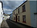
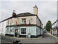
1

Weavers' houses, Chapel Street, Buckfastleigh
According to Palmer & Neaverson in The Textile Industry of South-West England (2005), this is a good example of a group of three storey houses used for weaving in the domestic woollen industry. The top floor has wooden slatting to allow ventilation for drying but it is not known whether the material drying was damp worsted, sized yarns or fulled cloth. Weaving could have been performed on the first or ground floors.
These are quite unlike the typical Yorkshire weavers' cottages.
Image: © Chris Allen
Taken: 5 Jun 2011
0.03 miles
2
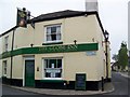
The Globe Inn, Bucklastleigh
A traditional public house known for its good food.
Image: © Maigheach-gheal
Taken: 13 May 2009
0.03 miles
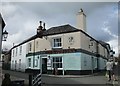
3

The King's Arms, Buckfastleigh
Public house with accommodation built circa 1820.
Image: © Maigheach-gheal
Taken: 13 May 2009
0.03 miles
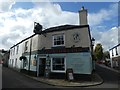
4
The Globe Inn, Buckfastleigh
Has a dramatic pub sign,
Image: © Jonathan Thacker
Taken: 16 Sep 2017
0.03 miles
5
The Globe Inn, Buckfastleigh
The sign is unusual - a spherical globe, not a two-dimensional picture
Image: © David Smith
Taken: 19 Oct 2019
0.04 miles
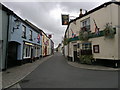
7
Buckfastleigh - The Globe Inn
Historic pub at the fork between Plymouth Road (l) and Chapel Street (r).
Image: © Colin Smith
Taken: 25 Jul 2021
0.04 miles
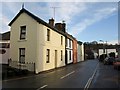
9
Plymouth Street, Buckfastleigh
At the junction of Chapel Street and Plymouth Street is The Globe Inn, a public house in Buckfastleigh village, in the Dartmoor National Park and Devon county of England.
Image: © Steven Haslington
Taken: 20 Sep 2012
0.04 miles
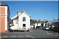
10
Houses on Plymouth Road, Buckfastleigh
The end terrace can be seen in Image The terrace faces St Luke's Church.
Image: © Derek Harper
Taken: 16 Jan 2009
0.05 miles