IMAGES TAKEN NEAR TO
Palstone Lane, SOUTH BRENT, TQ10 9NU
Introduction
This page details the photographs taken nearby to Palstone Lane, TQ10 9NU by members of the Geograph project.
The Geograph project started in 2005 with the aim of publishing, organising and preserving representative images for every square kilometre of Great Britain, Ireland and the Isle of Man.

There are currently over 7.5m images from over14,400 individuals and you can help contribute to the project by visiting https://www.geograph.org.uk
Image Map
Images are licensed for reuse under creativecommons.org/licenses/by-sa/2.0
Notes
- Clicking on the map will re-center to the selected point.
- The higher the marker number, the further away the image location is from the centre of the postcode.
Image Listing (25 Images Found)
Images are licensed for reuse under creativecommons.org/licenses/by-sa/2.0
Image
Details
Distance
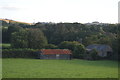
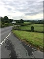
1
Palstone Lane
On the edge of South Brent.
Image: © jeff collins
Taken: 14 Jul 2020
0.06 miles
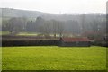
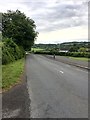
2
The B3372 Exeter Road
At Palstone. Heading away from South Brent.
Image: © jeff collins
Taken: 14 Jul 2020
0.07 miles
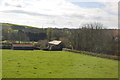
3
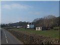
Buildings at Palstone
A mix of farm buildings and houses
Image: © David Smith
Taken: 29 Feb 2012
0.10 miles
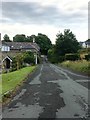
4
B3372 Exeter Road
Heading out of South Brent.
Image: © jeff collins
Taken: 14 Jul 2020
0.12 miles