IMAGES TAKEN NEAR TO
North Huish, SOUTH BRENT, TQ10 9NH
Introduction
This page details the photographs taken nearby to TQ10 9NH by members of the Geograph project.
The Geograph project started in 2005 with the aim of publishing, organising and preserving representative images for every square kilometre of Great Britain, Ireland and the Isle of Man.

There are currently over 7.5m images from over14,400 individuals and you can help contribute to the project by visiting https://www.geograph.org.uk
Image Map
Images are licensed for reuse under creativecommons.org/licenses/by-sa/2.0
Notes
- Clicking on the map will re-center to the selected point.
- The higher the marker number, the further away the image location is from the centre of the postcode.
Image Listing (18 Images Found)
Images are licensed for reuse under creativecommons.org/licenses/by-sa/2.0
Image
Details
Distance
1
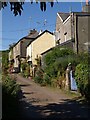
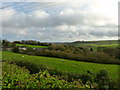
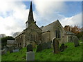
North Huish
The main street of the hamlet climbs a hill, and consists of a row of cottages facing the church across a field.
Image: © Derek Harper
Taken: 24 Jun 2009
0.00 miles
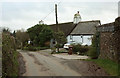
2
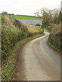
Lane, North Huish
Linking two parts of the disjointed hamlet. Ahead is Hillside Barn.
Image: © Derek Harper
Taken: 26 Nov 2019
0.05 miles
3
North Huish
Image: © Derek Harper
Taken: 24 Jun 2009
0.05 miles
4
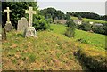
From the churchyard, North Huish
Looking across to North Huish Cottages.
Image: © Derek Harper
Taken: 24 Jul 2014
0.05 miles
6
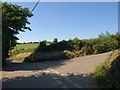
Lane junction, North Huish
The two lanes referred to in Image meet, on the east edge of the hamlet.
Image: © Derek Harper
Taken: 24 Jun 2009
0.05 miles
7
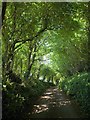
Dark lane, North Huish
A back lane completely overhung with trees that bypasses the main street of the hamlet.
Image: © Derek Harper
Taken: 24 Jun 2009
0.06 miles
8
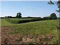
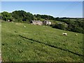
Field boundary near North Huish
From the same spot as Image, a view up the hill to a right-angled field boundary, doubtless a reminder of earlier boundaries now removed.
Image: © Derek Harper
Taken: 24 Jun 2009
0.09 miles
10
Church House, North Huish
"Probably a church house, now a private house. Probably early C17, possibly with C16 origins" https://historicengland.org.uk/listing/the-list/list-entry/1227876 .
Image: © Derek Harper
Taken: 26 Nov 2019
0.11 miles