IMAGES TAKEN NEAR TO
Wrangaton, SOUTH BRENT, TQ10 9GQ
Introduction
This page details the photographs taken nearby to TQ10 9GQ by members of the Geograph project.
The Geograph project started in 2005 with the aim of publishing, organising and preserving representative images for every square kilometre of Great Britain, Ireland and the Isle of Man.

There are currently over 7.5m images from over14,400 individuals and you can help contribute to the project by visiting https://www.geograph.org.uk
Image Map
Images are licensed for reuse under creativecommons.org/licenses/by-sa/2.0
Notes
- Clicking on the map will re-center to the selected point.
- The higher the marker number, the further away the image location is from the centre of the postcode.
Image Listing (16 Images Found)
Images are licensed for reuse under creativecommons.org/licenses/by-sa/2.0
Image
Details
Distance

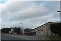
5
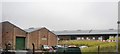
Business Park
The entrance to Anna Mill Business and distribution Park. On the B3213 between Wrangaton and Bittaford.
Image: © jeff collins
Taken: 1 Aug 2009
0.08 miles
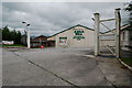
6
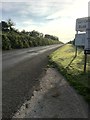
The B3213
Just outside Wrangaton Business Park. Looking in the direction of Wrangaton.
Image: © jeff collins
Taken: 17 Jun 2020
0.08 miles
7
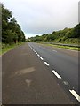
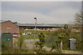
A38 Dual Carriageway
Heading towards Plymouth.
Image: © jeff collins
Taken: 26 Jul 2020
0.09 miles
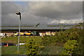
9

Layby on the A38 near Wrangaton Business Park
Image: © David Dixon
Taken: 11 Apr 2022
0.09 miles
10

Ugborough : Devon Expressway A38
Looking along the Devon Expressway A38.
Image: © Lewis Clarke
Taken: 3 Dec 2019
0.09 miles