IMAGES TAKEN NEAR TO
SOUTH BRENT, TQ10 9DY
Introduction
This page details the photographs taken nearby to TQ10 9DY by members of the Geograph project.
The Geograph project started in 2005 with the aim of publishing, organising and preserving representative images for every square kilometre of Great Britain, Ireland and the Isle of Man.

There are currently over 7.5m images from over14,400 individuals and you can help contribute to the project by visiting https://www.geograph.org.uk
Image Map
Images are licensed for reuse under creativecommons.org/licenses/by-sa/2.0
Notes
- Clicking on the map will re-center to the selected point.
- The higher the marker number, the further away the image location is from the centre of the postcode.
Image Listing (8 Images Found)
Images are licensed for reuse under creativecommons.org/licenses/by-sa/2.0
Image
Details
Distance
1
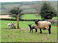
Curious Sheep
Sheep with lambs at Whinfield just outside South Brent.
Image: © Tony Atkin
Taken: 8 Apr 2012
0.05 miles
2
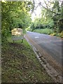
Approaching South Brent
From Harbourneford Cross.
Image: © jeff collins
Taken: 12 Jul 2020
0.12 miles
4
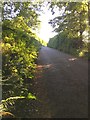
Hillside, South Brent
This view of Hillside was taken from by the Valve House Image looking east up and out of the village. The lane was probably the main route to Lower Dean and Buckfastleigh until the Toll roads were created in the C18th.
Image: © Adrian Platt
Taken: 7 Apr 2010
0.17 miles
5
Minor road to Harbourneford
From South Brent.
Image: © jeff collins
Taken: 12 Jul 2020
0.18 miles
6
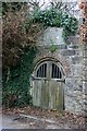
Former valve house in Hillside, South Brent
This was built in 1873 as part of the village's first public water supply. A reservoir was built behind this valve house collecting water from springs at Underhill, and this valve house controlled the supply down into the village. The inscription above the doors reads "As a token of gratitude to Sir W.R.Carew Bart, this tablet was erected January 1873". The supply had to be augmented around 1900 but remained in use until supplanted by the Avon Dam built around 1954. With thanks to Greg Wall for information in his two books, The First and The Second Book of South Brent, both published by Halsgrove.
Image: © Adrian Platt
Taken: 7 Apr 2010
0.23 miles
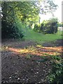
7
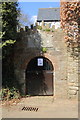
Former valve house in Hillside
Some effort has been taken to tidy this up since Image three years ago but someone has chosen to attach a notice about dog mess to the doors.
Image: © Guy Wareham
Taken: 6 Apr 2013
0.23 miles
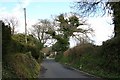
8
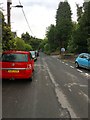
Hillside, South Brent
Road heading Northeast out of South Brent. Heading towards Harbourneford Cross.
Image: © jeff collins
Taken: 14 Jul 2020
0.25 miles