IMAGES TAKEN NEAR TO
Kerries Road, SOUTH BRENT, TQ10 9DA
Introduction
This page details the photographs taken nearby to Kerries Road, TQ10 9DA by members of the Geograph project.
The Geograph project started in 2005 with the aim of publishing, organising and preserving representative images for every square kilometre of Great Britain, Ireland and the Isle of Man.

There are currently over 7.5m images from over14,400 individuals and you can help contribute to the project by visiting https://www.geograph.org.uk
Image Map
Images are licensed for reuse under creativecommons.org/licenses/by-sa/2.0
Notes
- Clicking on the map will re-center to the selected point.
- The higher the marker number, the further away the image location is from the centre of the postcode.
Image Listing (53 Images Found)
Images are licensed for reuse under creativecommons.org/licenses/by-sa/2.0
Image
Details
Distance
1
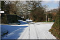
Kerries Road, South Brent
Kerries Road had been quieter than usual after the snow earlier in the morning.
See Image for the 2010 snow event.
Image: © Adrian Platt
Taken: 3 Feb 2009
0.02 miles
2
Kerries Road, South Brent
Looking down Kerries Road from the corner of Kerries Lane. The stainless steel of our new low energy street lights reflect the light beautifully ! On the distant hill are the cottages of the hamlet of Aish.
Image: © Adrian Platt
Taken: 3 Feb 2009
0.02 miles
3
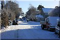
Kerries Road, South Brent
Snow covered Kerries Road with a number of abandoned cars. See Image
Image: © Adrian Platt
Taken: 18 Dec 2010
0.02 miles
4
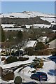
Crowder Park, with Brent Hill in the distance
The housing estate of Crowder Park was built in the mid fifties. The site was a camp during the 1939-45 war and was used by American forces prior to the D-Day landings; there were many such sites around the South Hams and Plymouth.
Image: © Ruth Sharville
Taken: 16 Nov 2008
0.05 miles
5
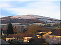
Brent Hill, from South Brent
Brent Hill, seen across the village with an appropriate dusting of snow for a Christmas Day afternoon !
Image: © Adrian Platt
Taken: 25 Dec 2004
0.07 miles
6
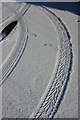
Tracks in the snow
These tyre tracks were at the Kerries Road and Crowder Park junction in South Brent. The snow was very fresh, dry, crisp and crunchy, and in the sunlight they appear as raised tracks but they really were normal depressions in the snow !
Image: © Adrian Platt
Taken: 3 Feb 2009
0.08 miles
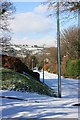
7
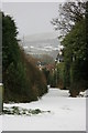
Brent Hill
Brent Hill, seen from South Brent. Snow still persists on Christmas Day a week after the main fall. Temperature last night about -7 degrees centigrade.
See Image for the approximately same scene 6 years ago.
Image: © Adrian Platt
Taken: 25 Dec 2010
0.08 miles
8
Kerries Lane, South Brent
Looking down Kerries Lane past Kerries Keep (with the red chimney pot). The slopes of Ugborough Beacon west of Peek Moor Gate are shrouded by the next snow shower.
Image: © Adrian Platt
Taken: 3 Feb 2009
0.08 miles
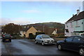
9
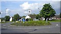
Roundabout, Sanderspool Cross, South Brent
Image: © Ruth Sharville
Taken: 29 May 2007
0.09 miles
10
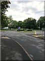
Roundabout
On the B3372 as it passes through South Brent.
Image: © jeff collins
Taken: 14 Jul 2020
0.09 miles