IMAGES TAKEN NEAR TO
Waterloo Road, TONBRIDGE, TN9 2SN
Introduction
This page details the photographs taken nearby to Waterloo Road, TN9 2SN by members of the Geograph project.
The Geograph project started in 2005 with the aim of publishing, organising and preserving representative images for every square kilometre of Great Britain, Ireland and the Isle of Man.

There are currently over 7.5m images from over14,400 individuals and you can help contribute to the project by visiting https://www.geograph.org.uk
Image Map
Images are licensed for reuse under creativecommons.org/licenses/by-sa/2.0
Notes
- Clicking on the map will re-center to the selected point.
- The higher the marker number, the further away the image location is from the centre of the postcode.
Image Listing (1241 Images Found)
Images are licensed for reuse under creativecommons.org/licenses/by-sa/2.0
Image
Details
Distance
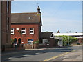
2
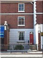
23 Salford Terrace
23 Salford Terrace was the headquarters of Holman Fred Stephens, who ran his network of independent railways from here.
Image: © Michael Roots
Taken: 13 Jul 2008
0.02 miles
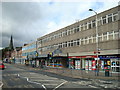
4
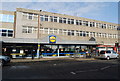
Lidl, Quarry Hill Rd
Cut price supermarket.
Image: © N Chadwick
Taken: 11 Mar 2009
0.03 miles
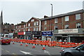
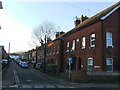
6
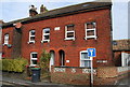
Terraced houses at end of Albert Road
Image: © Oast House Archive
Taken: 10 May 2009
0.03 miles
9
Fernacre, Albert Rd
A victorian cottage built in 1883
Image: © N Chadwick
Taken: 11 Mar 2009
0.03 miles