IMAGES TAKEN NEAR TO
Brantingham Close, TONBRIDGE, TN9 2QT
Introduction
This page details the photographs taken nearby to Brantingham Close, TN9 2QT by members of the Geograph project.
The Geograph project started in 2005 with the aim of publishing, organising and preserving representative images for every square kilometre of Great Britain, Ireland and the Isle of Man.

There are currently over 7.5m images from over14,400 individuals and you can help contribute to the project by visiting https://www.geograph.org.uk
Image Map
Images are licensed for reuse under creativecommons.org/licenses/by-sa/2.0
Notes
- Clicking on the map will re-center to the selected point.
- The higher the marker number, the further away the image location is from the centre of the postcode.
Image Listing (60 Images Found)
Images are licensed for reuse under creativecommons.org/licenses/by-sa/2.0
Image
Details
Distance
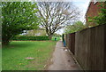
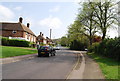
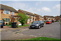
2
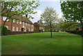
Houses around a green area off Upper Haysden Lane
Image: © N Chadwick
Taken: 19 Apr 2009
0.02 miles
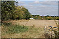
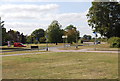
3
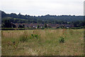
Molescroft Way
An estate of semi-detached homes, viewed across a field from Lower Haysden Lane.
Image: © Oast House Archive
Taken: 28 Jun 2009
0.02 miles
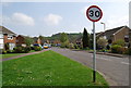
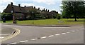
10
Street Furniture, junction of Lower Haysden Lane & Brook St
Image: © N Chadwick
Taken: 2 Oct 2009
0.10 miles