IMAGES TAKEN NEAR TO
College Avenue, TONBRIDGE, TN9 2PF
Introduction
This page details the photographs taken nearby to College Avenue, TN9 2PF by members of the Geograph project.
The Geograph project started in 2005 with the aim of publishing, organising and preserving representative images for every square kilometre of Great Britain, Ireland and the Isle of Man.

There are currently over 7.5m images from over14,400 individuals and you can help contribute to the project by visiting https://www.geograph.org.uk
Image Map
Images are licensed for reuse under creativecommons.org/licenses/by-sa/2.0
Notes
- Clicking on the map will re-center to the selected point.
- The higher the marker number, the further away the image location is from the centre of the postcode.
Image Listing (95 Images Found)
Images are licensed for reuse under creativecommons.org/licenses/by-sa/2.0
Image
Details
Distance
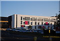
3
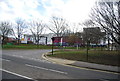
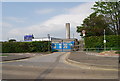
K College
Formerly known as West Kent College.
Image: © N Chadwick
Taken: 9 Feb 2014
0.08 miles
4
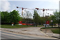
Renovating West Kent College
A major building programme is under way to modernise this large college
Image: © N Chadwick
Taken: 19 Apr 2009
0.08 miles
6
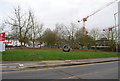
Rebuilding West Kent College, Brook St
The original 1960s building as been pulled down & a new college is being built
Image: © N Chadwick
Taken: 14 Mar 2009
0.09 miles