IMAGES TAKEN NEAR TO
St. Marys Road, TONBRIDGE, TN9 2LE
Introduction
This page details the photographs taken nearby to St. Marys Road, TN9 2LE by members of the Geograph project.
The Geograph project started in 2005 with the aim of publishing, organising and preserving representative images for every square kilometre of Great Britain, Ireland and the Isle of Man.

There are currently over 7.5m images from over14,400 individuals and you can help contribute to the project by visiting https://www.geograph.org.uk
Image Map
Images are licensed for reuse under creativecommons.org/licenses/by-sa/2.0
Notes
- Clicking on the map will re-center to the selected point.
- The higher the marker number, the further away the image location is from the centre of the postcode.
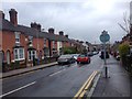
Image Listing (676 Images Found)
Images are licensed for reuse under creativecommons.org/licenses/by-sa/2.0
Image
Details
Distance
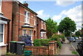
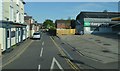
5
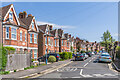
Woodfield Road
Semi-detached villas on Woodfield Road, with the first three pairs, now number nos 1 - 11, marked on the 1896 25 inch map and the rest on the 1908 edition. The first pair has a name plaque "Maidstone Villas".
Image: © Ian Capper
Taken: 20 Apr 2023
0.05 miles