IMAGES TAKEN NEAR TO
Gorham Drive, TONBRIDGE, TN9 2DU
Introduction
This page details the photographs taken nearby to Gorham Drive, TN9 2DU by members of the Geograph project.
The Geograph project started in 2005 with the aim of publishing, organising and preserving representative images for every square kilometre of Great Britain, Ireland and the Isle of Man.

There are currently over 7.5m images from over14,400 individuals and you can help contribute to the project by visiting https://www.geograph.org.uk
Image Map
Images are licensed for reuse under creativecommons.org/licenses/by-sa/2.0
Notes
- Clicking on the map will re-center to the selected point.
- The higher the marker number, the further away the image location is from the centre of the postcode.
Image Listing (64 Images Found)
Images are licensed for reuse under creativecommons.org/licenses/by-sa/2.0
Image
Details
Distance
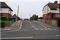
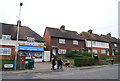
4
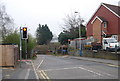
Traffic lights, southern end of Lodge Oak Lane bridge
Image: © N Chadwick
Taken: 3 Apr 2009
0.09 miles
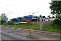
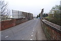
6
The A26 by Vale Rise, Tonbridge
The A26 forms the eastern bypass of the town centre and contains the local industrial area as you can see. The North Downs can be seen on the horizon as they can across much of North Kent.
Image: © David Howard
Taken: 15 Apr 2012
0.10 miles
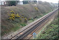
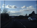
9
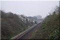
The A26, Tonbridge Eastern by pass crosses the railway line
Image: © N Chadwick
Taken: 3 Apr 2009
0.12 miles