IMAGES TAKEN NEAR TO
Drayton Road, TONBRIDGE, TN9 2BG
Introduction
This page details the photographs taken nearby to Drayton Road, TN9 2BG by members of the Geograph project.
The Geograph project started in 2005 with the aim of publishing, organising and preserving representative images for every square kilometre of Great Britain, Ireland and the Isle of Man.

There are currently over 7.5m images from over14,400 individuals and you can help contribute to the project by visiting https://www.geograph.org.uk
Image Map
Images are licensed for reuse under creativecommons.org/licenses/by-sa/2.0
Notes
- Clicking on the map will re-center to the selected point.
- The higher the marker number, the further away the image location is from the centre of the postcode.
Image Listing (536 Images Found)
Images are licensed for reuse under creativecommons.org/licenses/by-sa/2.0
Image
Details
Distance
1
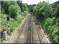
Railway to Royal Tunbridge Wells
This line leads to High Brooms and then Royal Tunbridge Wells, from Tonbridge.
The tunnel under Pembury Road is just seen in the background.
Image: © David Anstiss
Taken: 7 Jun 2009
0.02 miles
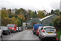
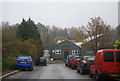
4
Drayton Road
Small industrial estate off Lavender Hill, built on the site of a former brickworks which operated until c.1915.
Image: © Ian Capper
Taken: 20 Apr 2023
0.02 miles
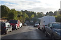
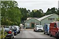
6
Drayton Rd Estate
A small industrial estate in the back streets.
Image: © N Chadwick
Taken: 14 Nov 2011
0.03 miles