IMAGES TAKEN NEAR TO
Lavender Hill, TONBRIDGE, TN9 2AT
Introduction
This page details the photographs taken nearby to Lavender Hill, TN9 2AT by members of the Geograph project.
The Geograph project started in 2005 with the aim of publishing, organising and preserving representative images for every square kilometre of Great Britain, Ireland and the Isle of Man.

There are currently over 7.5m images from over14,400 individuals and you can help contribute to the project by visiting https://www.geograph.org.uk
Image Map
Images are licensed for reuse under creativecommons.org/licenses/by-sa/2.0
Notes
- Clicking on the map will re-center to the selected point.
- The higher the marker number, the further away the image location is from the centre of the postcode.
Image Listing (571 Images Found)
Images are licensed for reuse under creativecommons.org/licenses/by-sa/2.0
Image
Details
Distance
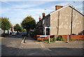
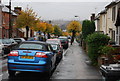
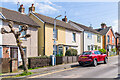
2
Lavender Hill
A street of Victorian terraced houses.
Image: © N Chadwick
Taken: 14 Nov 2011
0.02 miles

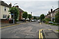
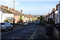
5
Lavender Hill, Tonbridge
Edwardian terraced housing in South Tonbridge.
Image: © N Chadwick
Taken: 10 Nov 2008
0.02 miles
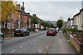
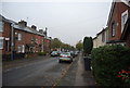
9
31 - 43 Lavender Hill
19th Century housing in Lavender Hill, with some houses marked on the 1867 1:500 plan and the remainder on the 1896 25 inch map. Nos 31 & 33, on the far right, have a name plaque "Ottoman Cottages".
Image: © Ian Capper
Taken: 20 Apr 2023
0.02 miles