IMAGES TAKEN NEAR TO
Priory Walk, TONBRIDGE, TN9 2AL
Introduction
This page details the photographs taken nearby to Priory Walk, TN9 2AL by members of the Geograph project.
The Geograph project started in 2005 with the aim of publishing, organising and preserving representative images for every square kilometre of Great Britain, Ireland and the Isle of Man.

There are currently over 7.5m images from over14,400 individuals and you can help contribute to the project by visiting https://www.geograph.org.uk
Image Map
Images are licensed for reuse under creativecommons.org/licenses/by-sa/2.0
Notes
- Clicking on the map will re-center to the selected point.
- The higher the marker number, the further away the image location is from the centre of the postcode.
Image Listing (1276 Images Found)
Images are licensed for reuse under creativecommons.org/licenses/by-sa/2.0
Image
Details
Distance

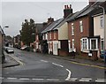

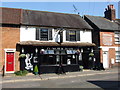
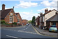
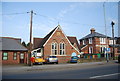
6
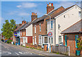
St Stephen's Street
Mid 19th Century housing, marked on the 1867 1:500 plan. The pub at no 11 is the Punch and Judy, previously the Gardener's Arms. The pair of houses nearer, nos 7 & 9, are marked on the 1867 plan as "Swift's Cottages" - although there is still a plaque on the front of the building, it appears blank.
Image: © Ian Capper
Taken: 20 Apr 2023
0.03 miles