IMAGES TAKEN NEAR TO
Cromer Street, TONBRIDGE, TN9 1UP
Introduction
This page details the photographs taken nearby to Cromer Street, TN9 1UP by members of the Geograph project.
The Geograph project started in 2005 with the aim of publishing, organising and preserving representative images for every square kilometre of Great Britain, Ireland and the Isle of Man.

There are currently over 7.5m images from over14,400 individuals and you can help contribute to the project by visiting https://www.geograph.org.uk
Image Map
Images are licensed for reuse under creativecommons.org/licenses/by-sa/2.0
Notes
- Clicking on the map will re-center to the selected point.
- The higher the marker number, the further away the image location is from the centre of the postcode.
Image Listing (759 Images Found)
Images are licensed for reuse under creativecommons.org/licenses/by-sa/2.0
Image
Details
Distance
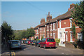
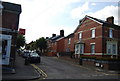
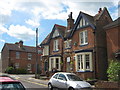
1
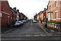
Cromer St
Victorian terraced housing near the railway station.
Image: © N Chadwick
Taken: 11 Mar 2009
0.01 miles
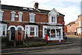
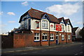
9
The Nelson Arms, Tonbridge
Public house on the junction of Cromer Street (in front) and Nelson Avenue (going behind pub).
Image: © David Anstiss
Taken: 7 Jun 2009
0.02 miles
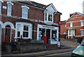
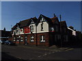
10
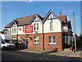
The Nelson Arms, Tonbridge
A Shepherd Neame pub on Nelson Avenue at the corner of Cromer Street.
Image: © Oast House Archive
Taken: 16 Sep 2011
0.02 miles