IMAGES TAKEN NEAR TO
High Street, TONBRIDGE, TN9 1SG
Introduction
This page details the photographs taken nearby to High Street, TN9 1SG by members of the Geograph project.
The Geograph project started in 2005 with the aim of publishing, organising and preserving representative images for every square kilometre of Great Britain, Ireland and the Isle of Man.

There are currently over 7.5m images from over14,400 individuals and you can help contribute to the project by visiting https://www.geograph.org.uk
Image Map
Images are licensed for reuse under creativecommons.org/licenses/by-sa/2.0
Notes
- Clicking on the map will re-center to the selected point.
- The higher the marker number, the further away the image location is from the centre of the postcode.
Image Listing (1807 Images Found)
Images are licensed for reuse under creativecommons.org/licenses/by-sa/2.0
Image
Details
Distance
9
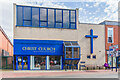
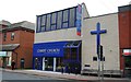
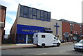
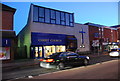
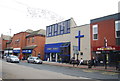
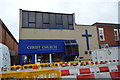
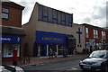
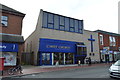
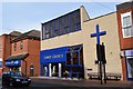
Christ Church URC
United Reformed Church in High Street, built in 1978 replacing a previous building on the same site dating from 1875. Major flooding of the River Medway in 1968 had caused significant damage to the foundations, and this is what led to the decision to rebuild.
Image: © Ian Capper
Taken: 20 Apr 2023
0.01 miles