IMAGES TAKEN NEAR TO
Brook Lane, TONBRIDGE, TN9 1PU
Introduction
This page details the photographs taken nearby to Brook Lane, TN9 1PU by members of the Geograph project.
The Geograph project started in 2005 with the aim of publishing, organising and preserving representative images for every square kilometre of Great Britain, Ireland and the Isle of Man.

There are currently over 7.5m images from over14,400 individuals and you can help contribute to the project by visiting https://www.geograph.org.uk
Image Map
Images are licensed for reuse under creativecommons.org/licenses/by-sa/2.0
Notes
- Clicking on the map will re-center to the selected point.
- The higher the marker number, the further away the image location is from the centre of the postcode.
Image Listing (103 Images Found)
Images are licensed for reuse under creativecommons.org/licenses/by-sa/2.0
Image
Details
Distance
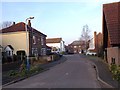

7
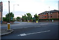
Hadlow Rd & Canon Lane junction
This is the beginning of Tonbridge's Easterly by-pass. The A26 heads off down Canon Lane to meet up with the A21 Westerly by-pass in south Tonbridge.
Image: © N Chadwick
Taken: 20 May 2009
0.06 miles