IMAGES TAKEN NEAR TO
Chiltern Way, TONBRIDGE, TN9 1NG
Introduction
This page details the photographs taken nearby to Chiltern Way, TN9 1NG by members of the Geograph project.
The Geograph project started in 2005 with the aim of publishing, organising and preserving representative images for every square kilometre of Great Britain, Ireland and the Isle of Man.

There are currently over 7.5m images from over14,400 individuals and you can help contribute to the project by visiting https://www.geograph.org.uk
Image Map
Images are licensed for reuse under creativecommons.org/licenses/by-sa/2.0
Notes
- Clicking on the map will re-center to the selected point.
- The higher the marker number, the further away the image location is from the centre of the postcode.
Image Listing (132 Images Found)
Images are licensed for reuse under creativecommons.org/licenses/by-sa/2.0
Image
Details
Distance
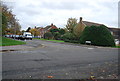
5
Rowan Mews, Dernier Rd
A recent infilling development.
Image: © N Chadwick
Taken: 20 May 2009
0.09 miles
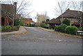
9
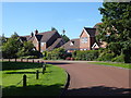
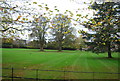
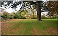
The Haydens
The Haydens is a very upmarket housing development in North Tonbridge, south of Yardley Park Road. It has its own private parkland, the edge of which is seen on the left here.
Image: © Marathon
Taken: 13 Aug 2017
0.11 miles
