IMAGES TAKEN NEAR TO
High Street, TONBRIDGE, TN9 1LD
Introduction
This page details the photographs taken nearby to High Street, TN9 1LD by members of the Geograph project.
The Geograph project started in 2005 with the aim of publishing, organising and preserving representative images for every square kilometre of Great Britain, Ireland and the Isle of Man.

There are currently over 7.5m images from over14,400 individuals and you can help contribute to the project by visiting https://www.geograph.org.uk
Image Map
Images are licensed for reuse under creativecommons.org/licenses/by-sa/2.0
Notes
- Clicking on the map will re-center to the selected point.
- The higher the marker number, the further away the image location is from the centre of the postcode.
Image Listing (732 Images Found)
Images are licensed for reuse under creativecommons.org/licenses/by-sa/2.0
Image
Details
Distance
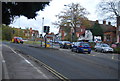
1
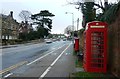
Approach to junction on Tonbridge High Street
View along the A227 looking towards the junction with the B245 (London Road)
Image: © Clint Mann
Taken: 24 Mar 2015
0.01 miles
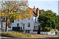
2
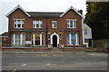
Hanover House
Grade II listed. https://www.britishlistedbuildings.co.uk/101121888-hanover-house-tonbridge-and-malling
Image: © N Chadwick
Taken: 17 Oct 2017
0.01 miles
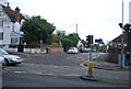


10
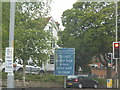
Box junction sign on London Road, Tonbridge
These went up when box junctions were introduced, now the authorities take it for granted people know and don't put up signs, maybe because they earn money each time someone's caught in one.
Image: © David Howard
Taken: 22 May 2016
0.02 miles