IMAGES TAKEN NEAR TO
Stafford Road, TONBRIDGE, TN9 1HT
Introduction
This page details the photographs taken nearby to Stafford Road, TN9 1HT by members of the Geograph project.
The Geograph project started in 2005 with the aim of publishing, organising and preserving representative images for every square kilometre of Great Britain, Ireland and the Isle of Man.

There are currently over 7.5m images from over14,400 individuals and you can help contribute to the project by visiting https://www.geograph.org.uk
Image Map
Images are licensed for reuse under creativecommons.org/licenses/by-sa/2.0
Notes
- Clicking on the map will re-center to the selected point.
- The higher the marker number, the further away the image location is from the centre of the postcode.
Image Listing (1499 Images Found)
Images are licensed for reuse under creativecommons.org/licenses/by-sa/2.0
Image
Details
Distance
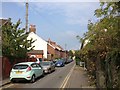
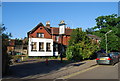
1
Stags Head sign
Sign for Image, a defunct former Whitbread pub on Stafford Road.
Image: © Oast House Archive
Taken: 16 Sep 2011
0.01 miles
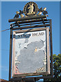
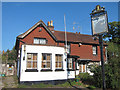
3
The Stag, Stafford Rd
This pub has been closed for many years now.
Image: © N Chadwick
Taken: 16 Jun 2010
0.01 miles
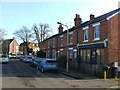
4
Stags Head, Tonbridge
A defunct pub on Stafford Road.
Image: © Oast House Archive
Taken: 16 Sep 2011
0.01 miles
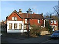
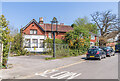
5
Formerly The Stags Head
Formerly a pub now a private residence.
Image: © N Chadwick
Taken: 31 Mar 2013
0.02 miles
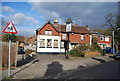
7
The Stag's Head
Pub in Stafford Road, originally built as two workmen's cottages and first granted a licence in the 1820s. It closed in the 1990s.
Image: © Ian Capper
Taken: 20 Apr 2023
0.02 miles
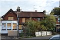
8
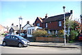
Formerly The Stags Head
Converted to a private residence.
Image: © N Chadwick
Taken: 21 Apr 2013
0.02 miles