IMAGES TAKEN NEAR TO
High Street, TONBRIDGE, TN9 1EL
Introduction
This page details the photographs taken nearby to High Street, TN9 1EL by members of the Geograph project.
The Geograph project started in 2005 with the aim of publishing, organising and preserving representative images for every square kilometre of Great Britain, Ireland and the Isle of Man.

There are currently over 7.5m images from over14,400 individuals and you can help contribute to the project by visiting https://www.geograph.org.uk
Image Map
Images are licensed for reuse under creativecommons.org/licenses/by-sa/2.0
Notes
- Clicking on the map will re-center to the selected point.
- The higher the marker number, the further away the image location is from the centre of the postcode.
Image Listing (1600 Images Found)
Images are licensed for reuse under creativecommons.org/licenses/by-sa/2.0
Image
Details
Distance
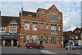
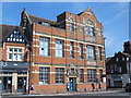
3
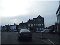
Tonbridge library from Vale Road junction
Image: © David Howard
Taken: 28 Apr 2013
0.00 miles
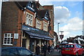
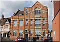
6
Quarry Hill Road / Barden Road / Avebury Road / High Street / Vale Road
Image: © Mike Quinn
Taken: 23 Jul 2016
0.00 miles
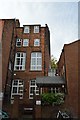
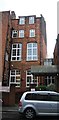
8
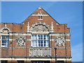
Tonbridge Library, Avebury Road - detail
See Image
Image: © Mike Quinn
Taken: 23 Jul 2016
0.00 miles