IMAGES TAKEN NEAR TO
High Street, TONBRIDGE, TN9 1AS
Introduction
This page details the photographs taken nearby to High Street, TN9 1AS by members of the Geograph project.
The Geograph project started in 2005 with the aim of publishing, organising and preserving representative images for every square kilometre of Great Britain, Ireland and the Isle of Man.

There are currently over 7.5m images from over14,400 individuals and you can help contribute to the project by visiting https://www.geograph.org.uk
Image Map
Images are licensed for reuse under creativecommons.org/licenses/by-sa/2.0
Notes
- Clicking on the map will re-center to the selected point.
- The higher the marker number, the further away the image location is from the centre of the postcode.
Image Listing (2026 Images Found)
Images are licensed for reuse under creativecommons.org/licenses/by-sa/2.0
Image
Details
Distance
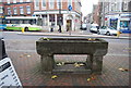
1
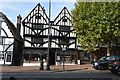
124, High St
Grade II* listed. https://britishlistedbuildings.co.uk/101363400-124-high-street-tonbridge-and-malling
Image: © N Chadwick
Taken: 12 Oct 2018
0.00 miles
7
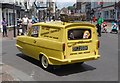
Del Boy at the Tonbridge Festival
Derek Trotter's Reliant took part in the parade for the Tonbridge Festival on 19th June 2016. Men wearing the masks of Rodney, Trigger and Boycie walked alongside.
Image: © Marathon
Taken: 19 Jun 2016
0.01 miles