IMAGES TAKEN NEAR TO
Ide Hill Road, EDENBRIDGE, TN8 7PG
Introduction
This page details the photographs taken nearby to Ide Hill Road, TN8 7PG by members of the Geograph project.
The Geograph project started in 2005 with the aim of publishing, organising and preserving representative images for every square kilometre of Great Britain, Ireland and the Isle of Man.

There are currently over 7.5m images from over14,400 individuals and you can help contribute to the project by visiting https://www.geograph.org.uk
Image Map
Images are licensed for reuse under creativecommons.org/licenses/by-sa/2.0
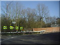
Notes
- Clicking on the map will re-center to the selected point.
- The higher the marker number, the further away the image location is from the centre of the postcode.
Image Listing (71 Images Found)
Images are licensed for reuse under creativecommons.org/licenses/by-sa/2.0
Image
Details
Distance
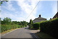
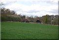
3

The outskirts of Bough Beech
This is the road from Bough Beech to Ide Hill, just as it is leaving Bough Beech.
Image: © Marathon
Taken: 3 May 2014
0.02 miles
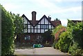
7
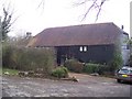
Clouts Farm Barn
Beside Clouts Farm in Bough Beech.
Image: © David Anstiss
Taken: 7 Feb 2010
0.05 miles
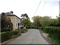
8
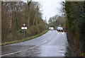
Clinton Lane (B2027)
The railway line is behind the trees on the left.
Image: © J.Hannan-Briggs
Taken: 12 Jan 2015
0.05 miles
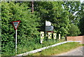
9
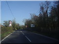
The B2027 approaching the railway bridge
Image: © David Howard
Taken: 1 Apr 2012
0.05 miles
10
Railway bridge on the B2027, Bough Beech
Image: © David Howard
Taken: 1 Apr 2012
0.06 miles