IMAGES TAKEN NEAR TO
Hever Castle Private Road, EDENBRIDGE, TN8 7NE
Introduction
This page details the photographs taken nearby to Hever Castle Private Road, TN8 7NE by members of the Geograph project.
The Geograph project started in 2005 with the aim of publishing, organising and preserving representative images for every square kilometre of Great Britain, Ireland and the Isle of Man.

There are currently over 7.5m images from over14,400 individuals and you can help contribute to the project by visiting https://www.geograph.org.uk
Image Map
Images are licensed for reuse under creativecommons.org/licenses/by-sa/2.0
Notes
- Clicking on the map will re-center to the selected point.
- The higher the marker number, the further away the image location is from the centre of the postcode.
Image Listing (55 Images Found)
Images are licensed for reuse under creativecommons.org/licenses/by-sa/2.0
Image
Details
Distance
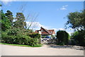
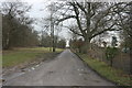
1
House seen from the Eden Valley Walk near Park Wood
The Eden Valley Walk follows the banks of the River Medway and its tributary the River Eden between Tonbridge and Edenbridge. Here it is on the edge of Park Wood on its way from Hever to Hill Hoath and Penshurst.
Image: © Marathon
Taken: 2 Jun 2013
0.02 miles
5
Waymarker, Eden Valley Walk
This walk is set in the Eden Valley, which for the most part is in the care of the National Trust. The walk was inaugurated by Kent County Council in 1991; a 15-mile route which links the Vanguard Way, where it passes to the west of Edenbridge, and the Wealdway in Tonbridge. The walk enters the High Weald Area of Outstanding Natural Beauty (AONB) and passes through parkland, woodland and open fields. The route is also rich in historical architecture, running close to both Hever and Tonbridge castles as well as many historic churches.
The walk begins just south of Haxted Mill where the Vanguard Way comes to Cernes Farm. The Eden Valley Walk cuts away to the north-east and then follows the modest river from which it takes its name towards Edenbridge.
From Edenbridge High street, coming from the station, turn left into Church St and enter the church grounds keeping left of the church. Continue to the far left corner of the church grounds; bear right following the wall until you come to an exit gateway. Now follow the waymarks through the residential area, they are on walls and lamp posts. The way curves southward, passes alongside Delaware Farm and comes to the Hever Road. Turn towards Edenbridge, but soon after across a field, pass beneath the railway and cross several more fields that bring you back to the railway near Hever Station.
A brief spell along a lane and you enter Hever, with a tile-hung pub on a corner, and the entrance to Hever Castle, birth place of Anne Boleyn, second wife of Henry VIII. The path takes you right beside the church. From the churchyard a footpath edges alongside a driveway, with the lake in the grounds of Hever Castle seen nearby. The way leads to Threshers Field, and then rises through woods to the hamlet of Hill Hoath. Leaving Hill Hoath at the halfway point along the walk, the stonework of Chiddingstone Castle is seen through trees to the north. A path of about half a mile provides an opportunity to visit the village, where refreshments are available at The Castle Inn, a beautiful timbered building dating from 1420.
A track goes between fields and woodland, crosses a country lane and comes to the farm buildings of Wat Stock. From here Penshurst is just over a mile, an old coach road traces the crest of ridge. As you come to the end of the coach road the walls of Penshurst Place appear out of sheep grazed parkland ahead. The way crosses this parkland and goes into Penshurst churchyard and out by way of the original Leicester Square. Now the walk takes a driveway alongside high walls that contain the gardens of Penshurst Place. A farm road continues, but a stile on the left bearing the Eden Valley logo soon directs you away from the concrete and up a steeply-rising meadow. Having reached the hilltop, another exposed farm road leads north-eastward with large fields on either side. Then the road slopes down to pass a pair of cottages at Killick's Bank, where a footpath cuts away to descend through meadows to the left bank of the Medway. At the end of the meadows the route crosses to the right bank by way of Ensfield Bridge. The way now follows the course of the Medway into Tonbridge, passing under the A21.
Image: © N Chadwick
Taken: 15 Feb 2010
0.04 miles
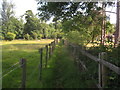
6

Alpacas along the Eden Valley Walk
Narrow path passes near a friendly farm.
Image: © Ibn Musa
Taken: 30 Mar 2013
0.05 miles
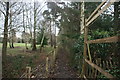
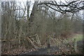
8
Footpath towards Park Wood
This path leads from Pigdown Lane past Tangle Wood towards Park Wood (in the background) and the Eden Valley Walk (long distance path), between Hever and Chiddingstone.
Image: © David Anstiss
Taken: 27 Jun 2010
0.07 miles
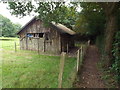
9
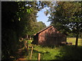
Barn beside the Eden Valley Walk
The long distance path heads towards Hever from Mill Lane.
Image: © David Anstiss
Taken: 27 Jun 2010
0.07 miles