IMAGES TAKEN NEAR TO
Uckfield Lane, EDENBRIDGE, TN8 7LR
Introduction
This page details the photographs taken nearby to Uckfield Lane, TN8 7LR by members of the Geograph project.
The Geograph project started in 2005 with the aim of publishing, organising and preserving representative images for every square kilometre of Great Britain, Ireland and the Isle of Man.

There are currently over 7.5m images from over14,400 individuals and you can help contribute to the project by visiting https://www.geograph.org.uk
Image Map (Loading...)


Getting Data...Please wait
Leaflet Map data © OpenStreetMap
Images are licensed for reuse under creativecommons.org/licenses/by-sa/2.0
Notes
- Clicking on the map will re-center to the selected point.
- The higher the marker number, the further away the image location is from the centre of the postcode.
Image Listing (87 Images Found)
Images are licensed for reuse under creativecommons.org/licenses/by-sa/2.0
Image
Details
Distance
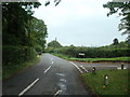
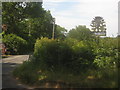
1

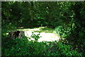
Field next to Uckfield Lane
This is the view from a quiet lane leading off Uckfield Lane, just north of Markbeech. Cow parsley and red campion can be seen in the verge.
Image: © Marathon
Taken: 2 Jun 2013
0.11 miles
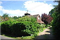
5
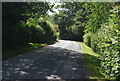
High Buckhurst
On a lane near Markbeech Village.
Image: © David Anstiss
Taken: 27 Jun 2010
0.15 miles
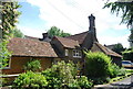
10
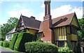
Markbeech Village Sign
On the junction of Uckfield Lane (on the left) and unnamed lane leading to Buck Hurst.
Image: © David Anstiss
Taken: 27 Jun 2010
0.17 miles