IMAGES TAKEN NEAR TO
Spode Lane, EDENBRIDGE, TN8 7HG
Introduction
This page details the photographs taken nearby to Spode Lane, TN8 7HG by members of the Geograph project.
The Geograph project started in 2005 with the aim of publishing, organising and preserving representative images for every square kilometre of Great Britain, Ireland and the Isle of Man.

There are currently over 7.5m images from over14,400 individuals and you can help contribute to the project by visiting https://www.geograph.org.uk
Image Map
Images are licensed for reuse under creativecommons.org/licenses/by-sa/2.0
Notes
- Clicking on the map will re-center to the selected point.
- The higher the marker number, the further away the image location is from the centre of the postcode.
Image Listing (44 Images Found)
Images are licensed for reuse under creativecommons.org/licenses/by-sa/2.0
Image
Details
Distance
2
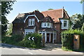
Round House Oast
This is found in the tiny hamlet of Gilridge. For more information about this oast see http://www.geograph.org.uk/photo/1242733
Image: © Marathon
Taken: 11 Oct 2014
0.02 miles
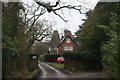
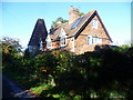
3
Round House, Spode Lane, Cowden, Kent
Image: © Oast House Archive
Taken: 8 Apr 2009
0.03 miles
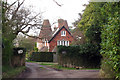
8

Gilridge House
A newly constructed Mansion.
Image: © N Chadwick
Taken: 14 Feb 2010
0.05 miles