IMAGES TAKEN NEAR TO
Hartfield Road, EDENBRIDGE, TN8 7DY
Introduction
This page details the photographs taken nearby to Hartfield Road, TN8 7DY by members of the Geograph project.
The Geograph project started in 2005 with the aim of publishing, organising and preserving representative images for every square kilometre of Great Britain, Ireland and the Isle of Man.

There are currently over 7.5m images from over14,400 individuals and you can help contribute to the project by visiting https://www.geograph.org.uk
Image Map
Images are licensed for reuse under creativecommons.org/licenses/by-sa/2.0
Notes
- Clicking on the map will re-center to the selected point.
- The higher the marker number, the further away the image location is from the centre of the postcode.
Image Listing (12 Images Found)
Images are licensed for reuse under creativecommons.org/licenses/by-sa/2.0
Image
Details
Distance
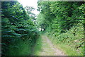
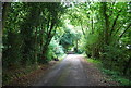
6
Bridleway & track diverge near Holywych House
Image: © N Chadwick
Taken: 27 Jun 2009
0.12 miles
10
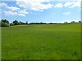
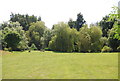
Thunder Field Bottom/Thunder Field
The name of the fields according to Hartfield's 1842 tithe map that have been merged to form a larger unit. Thunder Field Bottom is in the foreground whilst Thunder Field is on the slope.
Image: © Simon Carey
Taken: 31 May 2021
0.21 miles