IMAGES TAKEN NEAR TO
Tonbridge Road, EDENBRIDGE, TN8 7AT
Introduction
This page details the photographs taken nearby to Tonbridge Road, TN8 7AT by members of the Geograph project.
The Geograph project started in 2005 with the aim of publishing, organising and preserving representative images for every square kilometre of Great Britain, Ireland and the Isle of Man.

There are currently over 7.5m images from over14,400 individuals and you can help contribute to the project by visiting https://www.geograph.org.uk
Image Map (Loading...)


Getting Data...Please wait
Leaflet Map data © OpenStreetMap
Images are licensed for reuse under creativecommons.org/licenses/by-sa/2.0
Notes
- Clicking on the map will re-center to the selected point.
- The higher the marker number, the further away the image location is from the centre of the postcode.
Image Listing (15 Images Found)
Images are licensed for reuse under creativecommons.org/licenses/by-sa/2.0
Image
Details
Distance
2

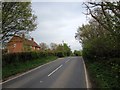
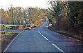
B2027 towards Chiddingstone Causeway
Passing over a tributary of the River Eden.
Image: © J.Hannan-Briggs
Taken: 12 Jan 2015
0.06 miles
3
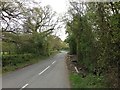
Hampkins Hill Road, near Chiddingstone
Image: © Chris Whippet
Taken: 20 Apr 2017
0.07 miles
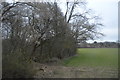
7
Junction of B2027 and Hale Oak Road
Image: © Julian P Guffogg
Taken: 23 Jan 2015
0.15 miles

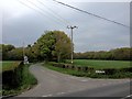
10
Hale Oak Road
Hale Oak Road runs from Sevenoaks Weald to the B2027 between Bough Beech and Chiddingstone Causeway. This is just up from the junction with the B2027.
Image: © Marathon
Taken: 18 Apr 2015
0.17 miles