IMAGES TAKEN NEAR TO
Main Road, EDENBRIDGE, TN8 6SW
Introduction
This page details the photographs taken nearby to Main Road, TN8 6SW by members of the Geograph project.
The Geograph project started in 2005 with the aim of publishing, organising and preserving representative images for every square kilometre of Great Britain, Ireland and the Isle of Man.

There are currently over 7.5m images from over14,400 individuals and you can help contribute to the project by visiting https://www.geograph.org.uk
Image Map (Loading...)


Getting Data...Please wait
Leaflet Map data © OpenStreetMap
Images are licensed for reuse under creativecommons.org/licenses/by-sa/2.0
Notes
- Clicking on the map will re-center to the selected point.
- The higher the marker number, the further away the image location is from the centre of the postcode.
Image Listing (4 Images Found)
Images are licensed for reuse under creativecommons.org/licenses/by-sa/2.0
Image
Details
Distance
1
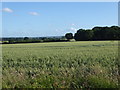
View towards Birds Wood
This view is from the footpath towards Coakham Farm and is just off Main Road near Crockham Park. Birds Wood is ahead to the right and the hills beyond Marsh Green are in the distance.
Image: © Marathon
Taken: 11 Jun 2017
0.12 miles
2
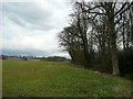
View east of the B2026
The wood is opposite Rushett and south of Oakfield Farm.
Image: © Jonathan Billinger
Taken: 26 Mar 2008
0.13 miles
3
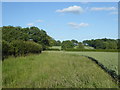
Footpath to Coakham Farm
This is just off Main Road near Crockham Park.
Image: © Marathon
Taken: 11 Jun 2017
0.20 miles
4
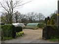
Ring Lodge Nursery
Situated by the B2026, north of Edenbridge, is this traditional nursery.
Image: © Jonathan Billinger
Taken: 26 Mar 2008
0.21 miles