IMAGES TAKEN NEAR TO
Merlin Drive, TN8 6QQ
Introduction
This page details the photographs taken nearby to Merlin Drive, TN8 6QQ by members of the Geograph project.
The Geograph project started in 2005 with the aim of publishing, organising and preserving representative images for every square kilometre of Great Britain, Ireland and the Isle of Man.

There are currently over 7.5m images from over14,400 individuals and you can help contribute to the project by visiting https://www.geograph.org.uk
Image Map (Loading...)


Getting Data...Please wait
Leaflet Map data © OpenStreetMap
Images are licensed for reuse under creativecommons.org/licenses/by-sa/2.0
Notes
- Clicking on the map will re-center to the selected point.
- The higher the marker number, the further away the image location is from the centre of the postcode.
Image Listing (25 Images Found)
Images are licensed for reuse under creativecommons.org/licenses/by-sa/2.0
Image
Details
Distance
1

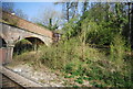
Railway to South Godstone
As seen from Image
This line leads from Tonbridge (via Edenbridge) towards South Godstone.
In the background is Dwelly Lane roadbridge.
Image: © David Anstiss
Taken: 10 Jul 2011
0.05 miles
2

Bombers foot crossing
A view west for a pedestrian about to cross south to north - a poor view. The bridge is 190 m away. The only specially listed hazard in Network Rail's risk assessment at the time was sun glare. The sighting in the other direction for anybody crossing is much better.
This crossing was risk assessed a year earlier at individual risk C (scale A bad - M good) and collective risk 10 (scale 1 bad - 13 good). The stated line speed was 85 mph. There were 66 trains per day, 'infrequent' users.
A later assessment in 2013 increased collective risk to 9, the only recorded changes being more trains (77) and a recognition of the poor sighting time. There was still no requirement for trains to 'whistle'.
Image: © Robin Webster
Taken: 5 May 2011
0.06 miles
3

Bombers foot crossing
A view west for a pedestrian about to cross north to south - not a great view. The bridge is 190 m away. The only specially listed hazard in Network Rail's risk assessment at the time was sun glare - the camera is suffering a little from it here. The sighting this way for anybody crossing in the other direction is worse.
This crossing was risk assessed a year earlier at individual risk C (scale A bad - M good) and collective risk 10 (scale 1 bad - 13 good). The stated line speed was 85 mph. There were 66 trains per day, 'infrequent' users.
A later assessment in 2013 increased collective risk to 9, the only recorded changes being more trains (77) and a recognition of the poor sighting time. There was still no requirement for trains to 'whistle'.
Image: © Robin Webster
Taken: 5 May 2011
0.07 miles
6
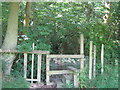
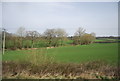
Steps and stile beside Staffhurst Wood
A footpath leads from Grant's Lane into the wood and to Dwelly Lane.
Image: © David Anstiss
Taken: 10 Jul 2011
0.07 miles
7
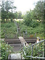
Bombers foot crossing
Anybody falling down the steps on the far side will come up against a fence, but not from this side. The only specially listed hazard in Network Rail's risk assessment at the time was sun glare, but the sighting in one direction of crossing in one direction of the track is far from good - see Image
This crossing was risk assessed a year earlier at individual risk C (scale A bad - M good) and collective risk 10 (scale 1 bad - 13 good). The stated line speed was 85 mph. There were 66 trains per day, 'infrequent' users.
A later assessment in 2013 increased collective risk to 9, the only recorded changes being more trains (77) and a recognition of the poor sighting time. There was still no requirement for trains to 'whistle'.
Image: © Robin Webster
Taken: 5 May 2011
0.07 miles
8
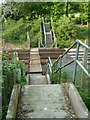
Level crossing near Butcherswood Wood
This level crossing is on a footpath from Grants Lane, towards to Dwelly Lane.
It crosses the line between Edenbridge and South Godstone.
Image: © David Anstiss
Taken: 10 Jul 2011
0.08 miles
10
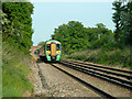
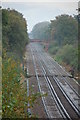
Eastbound train near Grants Lane
Unit 377 442 recedes from the level crossing of footpath 207 and approaches the Grants Lane bridge.
Image: © Robin Webster
Taken: 5 May 2011
0.10 miles