IMAGES TAKEN NEAR TO
Ide Hill Road, EDENBRIDGE, TN8 6NT
Introduction
This page details the photographs taken nearby to Ide Hill Road, TN8 6NT by members of the Geograph project.
The Geograph project started in 2005 with the aim of publishing, organising and preserving representative images for every square kilometre of Great Britain, Ireland and the Isle of Man.

There are currently over 7.5m images from over14,400 individuals and you can help contribute to the project by visiting https://www.geograph.org.uk
Image Map
Images are licensed for reuse under creativecommons.org/licenses/by-sa/2.0
Notes
- Clicking on the map will re-center to the selected point.
- The higher the marker number, the further away the image location is from the centre of the postcode.
Image Listing (14 Images Found)
Images are licensed for reuse under creativecommons.org/licenses/by-sa/2.0
Image
Details
Distance
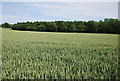
6
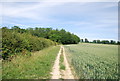
Footpath along the edge of a wheat field
The footpath is from Four Elms to Roodland Lane.
Image: © N Chadwick
Taken: 27 Jun 2010
0.19 miles
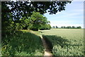
7
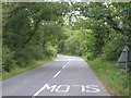
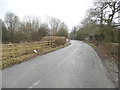
Green Lane
Road from Four Elms to Ide Hill.
Image: © Oast House Archive
Taken: 4 Jul 2010
0.19 miles
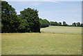
9
Toy's Hill Road, Four Elms
Looking towards Ide Hill Road
Image: © David Howard
Taken: 15 Mar 2015
0.24 miles
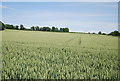
10
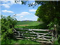
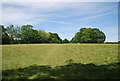
View towards Toy's Hill
This view from the footpath between Four Elms and Roodlands Farm looks alongside a woodland strip towards the distant Greensand Ridge at Toy's Hill.
Image: © Marathon
Taken: 3 May 2014
0.24 miles