IMAGES TAKEN NEAR TO
Skinners Lane, EDENBRIDGE, TN8 6LW
Introduction
This page details the photographs taken nearby to Skinners Lane, TN8 6LW by members of the Geograph project.
The Geograph project started in 2005 with the aim of publishing, organising and preserving representative images for every square kilometre of Great Britain, Ireland and the Isle of Man.

There are currently over 7.5m images from over14,400 individuals and you can help contribute to the project by visiting https://www.geograph.org.uk
Image Map
Images are licensed for reuse under creativecommons.org/licenses/by-sa/2.0
Notes
- Clicking on the map will re-center to the selected point.
- The higher the marker number, the further away the image location is from the centre of the postcode.
Image Listing (38 Images Found)
Images are licensed for reuse under creativecommons.org/licenses/by-sa/2.0
Image
Details
Distance
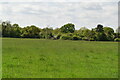
1
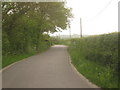
Skinners Lane
This lane leads from the B2027 Four Elms Road, towards Skinners Farm.
Image: © David Anstiss
Taken: 16 May 2010
0.03 miles
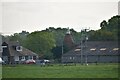
2
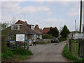
Veterinary Clinic - Edenbridge
This veterinary clinic is on the outskirts of Edenbridge and near the sewage works. The Eden Valley Walk runs close by.
Image: © Jean Barrow
Taken: 18 Apr 2006
0.06 miles
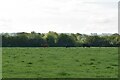
3
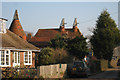
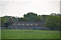
Oast House, Skinners Farm, Four Elms Road, Edenbridge, Kent
Image: © Oast House Archive
Taken: 29 Dec 2008
0.09 miles
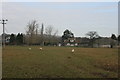
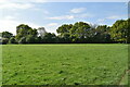
10
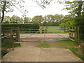
Footpath crosses Skinners Lane
A footpath from Four Elms Road, the path crosses lane leading left towards Skinners Farm. The path leads towards Forge Croft, Edenbridge.
Image: © David Anstiss
Taken: 16 May 2010
0.14 miles