IMAGES TAKEN NEAR TO
Homestead Road, EDENBRIDGE, TN8 6JD
Introduction
This page details the photographs taken nearby to Homestead Road, TN8 6JD by members of the Geograph project.
The Geograph project started in 2005 with the aim of publishing, organising and preserving representative images for every square kilometre of Great Britain, Ireland and the Isle of Man.

There are currently over 7.5m images from over14,400 individuals and you can help contribute to the project by visiting https://www.geograph.org.uk
Image Map (Loading...)


Getting Data...Please wait
Leaflet Map data © OpenStreetMap
Images are licensed for reuse under creativecommons.org/licenses/by-sa/2.0
Notes
- Clicking on the map will re-center to the selected point.
- The higher the marker number, the further away the image location is from the centre of the postcode.
Image Listing (29 Images Found)
Images are licensed for reuse under creativecommons.org/licenses/by-sa/2.0
Image
Details
Distance
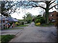
4
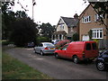
The Last House on the Road, Edenbridge, Kent
The houses on Fairmead Road, Edenbridge enjoy an excellent location, with open country to the east, as well as all the facilities of this pleasant Kentish town easily accessible. This photograph shows the most easterly house on Fairmead Road. The less than ideal viewpoint was necessitated by a sharp squall which forced your photographer to seek cover underneath trees.
Image: © Dr Neil Clifton
Taken: 22 Jul 2006
0.13 miles
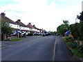
7
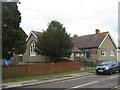
St. Paulinus Church Centre
Church Hall and community centre on Hillcrest Road.
It is also St. Paulinus Pre-school in the mornings, then a Dance, Judo, Stamp and Art Club.
Image: © David Anstiss
Taken: 13 Mar 2010
0.14 miles
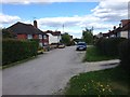
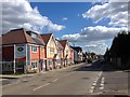
8
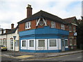
Closed Shop, Marlpit Hill
This interesting building is on the junction of Main Road (in front) and Hilders Lane (on the left). It is currently an office for an air conditioning company.
Image: © David Anstiss
Taken: 13 Mar 2010
0.14 miles
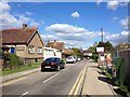
9
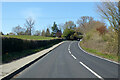
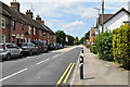
B2026 Main Road
Towards Crockham Hill and Westerham.
Image: © Robin Webster
Taken: 17 Apr 2021
0.14 miles