IMAGES TAKEN NEAR TO
Main Road, EDENBRIDGE, TN8 6HY
Introduction
This page details the photographs taken nearby to Main Road, TN8 6HY by members of the Geograph project.
The Geograph project started in 2005 with the aim of publishing, organising and preserving representative images for every square kilometre of Great Britain, Ireland and the Isle of Man.

There are currently over 7.5m images from over14,400 individuals and you can help contribute to the project by visiting https://www.geograph.org.uk
Image Map
Images are licensed for reuse under creativecommons.org/licenses/by-sa/2.0
Notes
- Clicking on the map will re-center to the selected point.
- The higher the marker number, the further away the image location is from the centre of the postcode.
Image Listing (111 Images Found)
Images are licensed for reuse under creativecommons.org/licenses/by-sa/2.0
Image
Details
Distance
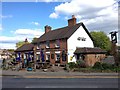
3
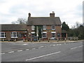
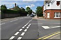
The Swan Pub, Marlpit Hill
On the junction of the B2026 Main Road (in front) and Swan Lane (heading left).
Image: © David Anstiss
Taken: 13 Mar 2010
0.04 miles
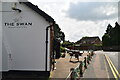
4
Rear of The Swan pub and car park, Swan Lane
Image: © David Howard
Taken: 22 Apr 2012
0.04 miles
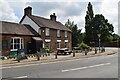
6
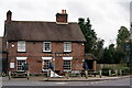
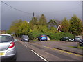
Marlpit Hill
Marlpit Hill is now at the northern edge of Edenbridge, which has expanded over the years.
The Swan stands at the junction of Swan Lane and Main Road.
Image: © Peter Trimming
Taken: 26 Nov 2022
0.04 miles
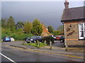
7
Station Road Edenbridge
By The Swan public house
Image: © David Howard
Taken: 22 Apr 2012
0.04 miles
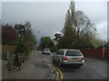
9
Swan Lane, Edenbridge
The Swan pub car park is on the right
Image: © David Howard
Taken: 22 Apr 2012
0.05 miles